Boevange-sur-Attert geodata
Boevange-sur-Attert (Mersch) is a seat of a third-order administrative division; located in Luxembourg in Europe/Luxembourg (GMT+2) time zone. With population of 576 people, there are 140 cities with bigger population in this country. Compared to other cities in Luxembourg, 74% of cities are located further ↓South; 68.4% of cities are located further →East and 61% of cities have higher elevation than Boevange-sur-Attert. Note1


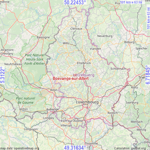
Boevange-sur-Attert GPS coordinates[2]
49° 46' 21.216" North, 6° 0' 55.152" East
| Map corner | latitude | longitude |
|---|---|---|
| Upper-left | 50.22453°, | 5.3122° |
| Center: | 49.77256°, | 6.01532° |
| Lower-right: | 49.31634°, | 6.71845° |
| Map W x H: | 101×101 km | = 62.8×62.8mi |
| max Lat: | 50.13722° ⇑26% North |
| Boevange-sur-Attert: | 49.77256° |
| min Lat: | ⇓74% South 49.45964° |
| min Long | Boevange-sur-At | max Long |
| 5.76583° | 6.01532° | 6.50532° |
| W 31.6%⇐ | ⇒68.4% E |
Elevation
Elevation of Boevange-sur-Attert is 265 m = 869 ft, and this is 17 m = 56 ft below average elevation for this country.
| Max E: |
502 m = 1647 ft | 61% |
| Avg. | 282 m = 925 ft | |
| Boevange-sur-Attert | 265 m = 869 ft | |
Min E: |
143 m = 469 ft | 39% |
See also: Luxembourg elevation on elevation.city.
Geographical zone
Boevange-sur-Attert is located in North temperate zone (between Tropic of Cancer and the Arctic Circle). Distance of this North polar circle is 1867 km =1160.1 mi to North.| Distance of | km | miles | from Boevange-sur-Attert |
|---|---|---|---|
| North Pole | 4472.9 | 2779.3 | to North |
| Arctic Circle | 1867 | 1160.1 | to North |
| Tropic Cancer | 2928.3 | 1819.6 | to South |
| Equator | 5534.2 | 3438.8 | to South |


Nearby cities:
15 places around Boevange-sur-Attert: (largest is in red/bold)
• Beringen
7.5 km =4.7 mi,  102°
102°
• Bettborn
5.9 km =3.7 mi,  295°
295°
• Bissen
4 km =2.5 mi,  65°
65°
• Brouch
4.1 km =2.5 mi,  172°
172°
• Colmar
7.2 km =4.5 mi,  54°
54°
• Grosbous
7 km =4.3 mi,  330°
330°
• Mersch
7 km =4.3 mi,  111°
111°
• Mertzig
6.8 km =4.2 mi,  355°
355°
• Platen
6.1 km =3.8 mi,  287°
287°
• Reckange
5.5 km =3.4 mi,  117°
117°
• Rollingen
7.9 km =4.9 mi, 115°
• Saeul
5.5 km =3.4 mi,  202°
202°
• Tuntange
6.1 km =3.8 mi,  183°
183°
• Useldange
2.4 km =1.5 mi,  262°
262°
• Vichten
3.6 km =2.2 mi,  342°
342°
Sources, notices
• [Note1] Compared only with cities in Luxembourg existing in our database
• [Src1] Map data: © OpenStreetMap contributors (CC-BY-SA)
• [Src2] Other city data from geonames.org with taken over terms of usage.
• [Src3] Geographical zone / Annual Mean Temperature by Robert A. Rohde @ Wikipedia
