Bissen geodata
Bissen (Mersch) is a seat of a third-order administrative division; located in Luxembourg in Europe/Luxembourg (GMT+2) time zone. With population of 2,547 people, there are 29 cities with bigger population in this country. Compared to other cities in Luxembourg, 76.3% of cities are located further ↓South; 59.9% of cities are located further →East and 83.1% of cities have higher elevation than Bissen. Note1


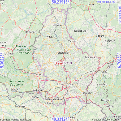
Bissen GPS coordinates[2]
49° 47' 14.388" North, 6° 3' 55.44" East
| Map corner | latitude | longitude |
|---|---|---|
| Upper-left | 50.23916°, | 5.36228° |
| Center: | 49.78733°, | 6.0654° |
| Lower-right: | 49.33124°, | 6.76853° |
| Map W x H: | 101×100.9 km | = 62.8×62.7mi |
| max Lat: | 50.13722° ⇑23.7% North |
| Bissen: | 49.78733° |
| min Lat: | ⇓76.3% South 49.45964° |
| min Long | Bissen | max Long |
| 5.76583° | 6.0654° | 6.50532° |
| W 40.1%⇐ | ⇒59.9% E |
Elevation
Elevation of Bissen is 221 m = 725 ft, and this is 61 m = 200 ft below average elevation for this country.
| Max E: |
502 m = 1647 ft | 83.1% |
| Avg. | 282 m = 925 ft | |
| Bissen | 221 m = 725 ft | |
Min E: |
143 m = 469 ft | 16.9% |
See also: Luxembourg elevation on elevation.city.
Geographical zone
Bissen is located in North temperate zone (between Tropic of Cancer and the Arctic Circle). Distance of this North polar circle is 1865.3 km =1159 mi to North.| Distance of | km | miles | from Bissen |
|---|---|---|---|
| North Pole | 4471.2 | 2778.3 | to North |
| Arctic Circle | 1865.3 | 1159 | to North |
| Tropic Cancer | 2929.9 | 1820.6 | to South |
| Equator | 5535.8 | 3439.8 | to South |


Nearby cities:
15 places around Bissen: (largest is in red/bold)
• Beringen
4.9 km =3 mi,  131°
131°
• Boevange-sur-Attert
4 km =2.5 mi,  245°
245°
• Brouch
6.5 km =4 mi,  208°
208°
• Colmar
3.4 km =2.1 mi,  41°
41°
• Ettelbruck
7.2 km =4.5 mi,  22°
22°
• Mersch
5.2 km =3.2 mi,  145°
145°
• Mertzig
6.6 km =4.1 mi,  321°
321°
• Niederfeulen
7.7 km =4.8 mi,  350°
350°
• Nommern
7.8 km =4.8 mi,  90°
90°
• Reckange
4.4 km =2.7 mi,  163°
163°
• Rollingen
6.2 km =3.9 mi, 145°
• Schieren
5.4 km =3.4 mi,  26°
26°
• Useldange
6.3 km =3.9 mi, 251°
• Vichten
5 km =3.1 mi,  290°
290°
• Warken
8.1 km =5 mi,  9°
9°
Sources, notices
• [Note1] Compared only with cities in Luxembourg existing in our database
• [Src1] Map data: © OpenStreetMap contributors (CC-BY-SA)
• [Src2] Other city data from geonames.org with taken over terms of usage.
• [Src3] Geographical zone / Annual Mean Temperature by Robert A. Rohde @ Wikipedia
