Vichten geodata
Vichten (Redange) is a seat of a third-order administrative division; located in Luxembourg in Europe/Luxembourg (GMT+2) time zone. With population of 764 people, there are 105 cities with bigger population in this country. Compared to other cities in Luxembourg, 78.5% of cities are located further ↓South; 72.9% of cities are located further →East and 50.3% of cities have lower elevation than Vichten. Note1


Vichten GPS coordinates[2]
49° 48' 11.016" North, 6° 0' 0" East
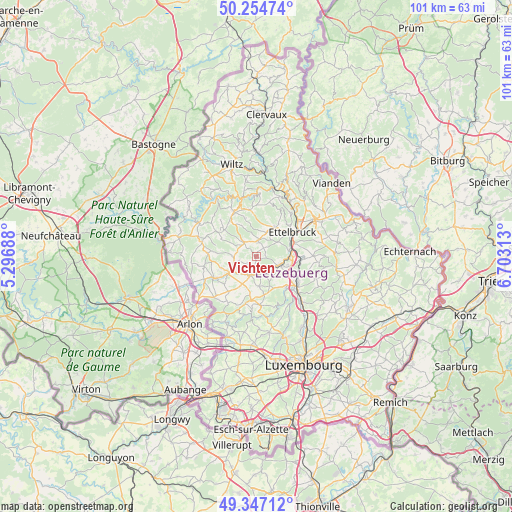
| Map corner | latitude | longitude |
|---|---|---|
| Upper-left | 50.25474°, | 5.29688° |
| Center: | 49.80306°, | 6° |
| Lower-right: | 49.34712°, | 6.70313° |
| Map W x H: | 100.9×100.9 km | = 62.7×62.7mi |
| max Lat: | 50.13722° ⇑21.5% North |
| Vichten: | 49.80306° |
| min Lat: | ⇓78.5% South 49.45964° |
| min Long | Vichten | max Long |
| 5.76583° | 6° | 6.50532° |
| W 27.1%⇐ | ⇒72.9% E |
Elevation
Elevation of Vichten is 283 m = 928 ft, and this is 1 m = 3 ft above average elevation for this country.
| Max E: |
502 m = 1647 ft | 49.7% |
| Vichten | 283 m 928 ft | |
| Avg. | 282 m = 925 ft | |
Min E: |
143 m = 469 ft | 50.3% |
See also: Luxembourg elevation on elevation.city.
Geographical zone
Vichten is located in North temperate zone (between Tropic of Cancer and the Arctic Circle). Distance of this North polar circle is 1863.6 km =1158 mi to North.| Distance of | km | miles | from Vichten |
|---|---|---|---|
| North Pole | 4469.5 | 2777.2 | to North |
| Arctic Circle | 1863.6 | 1158 | to North |
| Tropic Cancer | 2931.7 | 1821.7 | to South |
| Equator | 5537.6 | 3440.9 | to South |


Nearby cities:
15 places around Vichten: (largest is in red/bold)
• Bettborn
4.3 km =2.7 mi,  258°
258°
• Bissen
5 km =3.1 mi,  110°
110°
• Boevange-sur-Attert
3.6 km =2.2 mi,  162°
162°
• Brouch
7.6 km =4.7 mi,  167°
167°
• Colmar
7 km =4.3 mi,  83°
83°
• Grosbous
3.6 km =2.2 mi,  319°
319°
• Mertzig
3.5 km =2.2 mi,  8°
8°
• Niederfeulen
6.7 km =4.2 mi,  30°
30°
• Platen
5 km =3.1 mi,  252°
252°
• Reckange
8.4 km =5.2 mi,  134°
134°
• Saeul
8.5 km =5.3 mi,  186°
186°
• Schieren
7.7 km =4.8 mi,  66°
66°
• Useldange
3.9 km =2.4 mi,  198°
198°
• Wahl
7.7 km =4.8 mi,  299°
299°
• Warken
8.7 km =5.4 mi,  44°
44°
Sources, notices
• [Note1] Compared only with cities in Luxembourg existing in our database
• [Src1] Map data: © OpenStreetMap contributors (CC-BY-SA)
• [Src2] Other city data from geonames.org with taken over terms of usage.
• [Src3] Geographical zone / Annual Mean Temperature by Robert A. Rohde @ Wikipedia
