Bourglinster geodata
Bourglinster (Grevenmacher) is a populated place; located in Luxembourg in Europe/Luxembourg (GMT+2) time zone. With population of 680 people, there are 116 cities with bigger population in this country. Compared to other cities in Luxembourg, 62.1% of cities are located further ↓South; 69.5% of cities are located further ←West and 85.9% of cities have lower elevation than Bourglinster. Note1


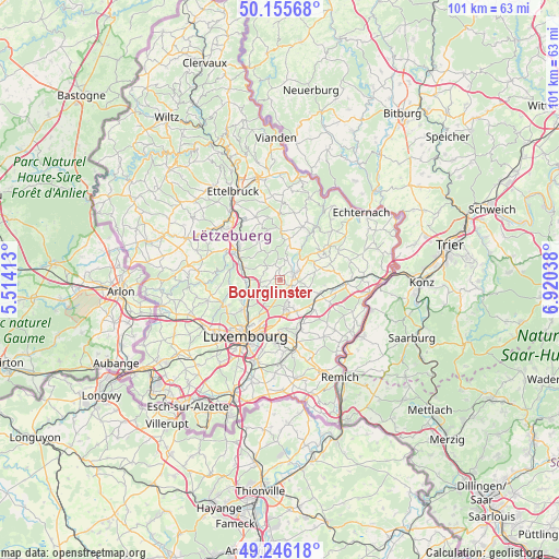
Bourglinster GPS coordinates[2]
49° 42' 11.016" North, 6° 13' 2.1" East
| Map corner | latitude | longitude |
|---|---|---|
| Upper-left | 50.15568°, | 5.51413° |
| Center: | 49.70306°, | 6.21725° |
| Lower-right: | 49.24618°, | 6.92038° |
| Map W x H: | 101.1×101.1 km | = 62.8×62.8mi |
| max Lat: | 50.13722° ⇑37.9% North |
| Bourglinster: | 49.70306° |
| min Lat: | ⇓62.1% South 49.45964° |
| min Long | Bourglinster | max Long |
| 5.76583° | 6.21725° | 6.50532° |
| W 69.5%⇐ | ⇒30.5% E |
Elevation
Elevation of Bourglinster is 336 m = 1102 ft, and this is 54 m = 177 ft above average elevation for this country.
| Max E: |
502 m = 1647 ft | 14.1% |
| Bourglinster | 336 m 1102 ft | |
| Avg. | 282 m = 925 ft | |
Min E: |
143 m = 469 ft | 85.9% |
See also: Luxembourg elevation on elevation.city.
Geographical zone
Bourglinster is located in North temperate zone (between Tropic of Cancer and the Arctic Circle). Distance of this North polar circle is 1874.7 km =1164.9 mi to North.| Distance of | km | miles | from Bourglinster |
|---|---|---|---|
| North Pole | 4480.6 | 2784.1 | to North |
| Arctic Circle | 1874.7 | 1164.9 | to North |
| Tropic Cancer | 2920.5 | 1814.7 | to South |
| Equator | 5526.5 | 3434 | to South |


Nearby cities:
15 places around Bourglinster: (largest is in red/bold)
• Bofferdange
5.7 km =3.5 mi,  256°
256°
• Fischbach
5.2 km =3.2 mi,  335°
335°
• Gonderange
2.2 km =1.4 mi,  112°
112°
• Heffingen
7.5 km =4.7 mi,  12°
12°
• Heisdorf
6.4 km =4 mi,  237°
237°
• Helmdange
5.5 km =3.4 mi, 259°
• Junglinster
2.6 km =1.6 mi,  79°
79°
• Lintgen
6.6 km =4.1 mi,  288°
288°
• Lorentzweiler
5.4 km =3.4 mi,  267°
267°
• Müllendorf
6.8 km =4.2 mi,  248°
248°
• Niederanven
6.5 km =4 mi,  150°
150°
• Oberanven
5.4 km =3.4 mi,  159°
159°
• Rameldange
4.9 km =3 mi,  167°
167°
• Roodt-sur-Syre
7.4 km =4.6 mi,  123°
123°
• Steinsel
7.3 km =4.5 mi, 246°
Sources, notices
• [Note1] Compared only with cities in Luxembourg existing in our database
• [Src1] Map data: © OpenStreetMap contributors (CC-BY-SA)
• [Src2] Other city data from geonames.org with taken over terms of usage.
• [Src3] Geographical zone / Annual Mean Temperature by Robert A. Rohde @ Wikipedia
