Gonderange geodata
Gonderange (Grevenmacher) is a populated place; located in Luxembourg in Europe/Luxembourg (GMT+2) time zone. With population of 1,469 people, there are 53 cities with bigger population in this country. Compared to other cities in Luxembourg, 59.3% of cities are located further ↓South; 74.6% of cities are located further ←West and 81.4% of cities have lower elevation than Gonderange. Note1


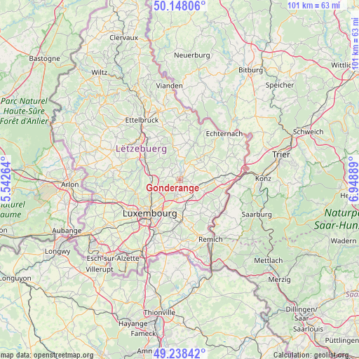
Gonderange GPS coordinates[2]
49° 41' 43.332" North, 6° 14' 44.772" East
| Map corner | latitude | longitude |
|---|---|---|
| Upper-left | 50.14806°, | 5.54264° |
| Center: | 49.69537°, | 6.24577° |
| Lower-right: | 49.23842°, | 6.94889° |
| Map W x H: | 101.1×101.1 km | = 62.8×62.8mi |
| max Lat: | 50.13722° ⇑40.7% North |
| Gonderange: | 49.69537° |
| min Lat: | ⇓59.3% South 49.45964° |
| min Long | Gonderange | max Long |
| 5.76583° | 6.24577° | 6.50532° |
| W 74.6%⇐ | ⇒25.4% E |
Elevation
Elevation of Gonderange is 331 m = 1086 ft, and this is 49 m = 161 ft above average elevation for this country.
| Max E: |
502 m = 1647 ft | 18.6% |
| Gonderange | 331 m 1086 ft | |
| Avg. | 282 m = 925 ft | |
Min E: |
143 m = 469 ft | 81.4% |
See also: Luxembourg elevation on elevation.city.
Geographical zone
Gonderange is located in North temperate zone (between Tropic of Cancer and the Arctic Circle). Distance of this North polar circle is 1875.6 km =1165.4 mi to North.| Distance of | km | miles | from Gonderange |
|---|---|---|---|
| North Pole | 4481.5 | 2784.7 | to North |
| Arctic Circle | 1875.6 | 1165.4 | to North |
| Tropic Cancer | 2919.7 | 1814.2 | to South |
| Equator | 5525.6 | 3433.4 | to South |


Nearby cities:
15 places around Gonderange: (largest is in red/bold)
• Betzdorf
7.6 km =4.7 mi,  100°
100°
• Bofferdange
7.6 km =4.7 mi,  266°
266°
• Bourglinster
2.2 km =1.4 mi,  292°
292°
• Fischbach
7 km =4.3 mi,  323°
323°
• Flaxweiler
7.7 km =4.8 mi,  114°
114°
• Helmdange
7.5 km =4.7 mi, 268°
• Junglinster
1.4 km =0.9 mi,  21°
21°
• Lorentzweiler
7.5 km =4.7 mi,  275°
275°
• Mensdorf
6.2 km =3.9 mi,  137°
137°
• Münsbach
7.1 km =4.4 mi,  168°
168°
• Niederanven
5 km =3.1 mi, 166°
• Oberanven
4.2 km =2.6 mi,  182°
182°
• Rameldange
4 km =2.5 mi,  193°
193°
• Roodt-sur-Syre
5.2 km =3.2 mi,  128°
128°
• Uebersyren
7.4 km =4.6 mi,  162°
162°
Sources, notices
• [Note1] Compared only with cities in Luxembourg existing in our database
• [Src1] Map data: © OpenStreetMap contributors (CC-BY-SA)
• [Src2] Other city data from geonames.org with taken over terms of usage.
• [Src3] Geographical zone / Annual Mean Temperature by Robert A. Rohde @ Wikipedia
