Rameldange geodata
Rameldange (Luxembourg) is a populated place; located in Luxembourg in Europe/Luxembourg (GMT+2) time zone. With population of 682 people, there are 113 cities with bigger population in this country. Compared to other cities in Luxembourg, 52% of cities are located further ↑North; 72.9% of cities are located further ←West and 81.4% of cities have lower elevation than Rameldange. Note1


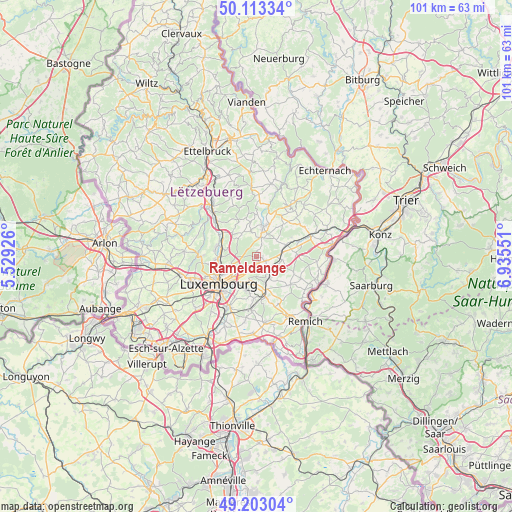
Rameldange GPS coordinates[2]
49° 39' 37.152" North, 6° 13' 56.568" East
| Map corner | latitude | longitude |
|---|---|---|
| Upper-left | 50.11334°, | 5.52926° |
| Center: | 49.66032°, | 6.23238° |
| Lower-right: | 49.20304°, | 6.93551° |
| Map W x H: | 101.2×101.2 km | = 62.9×62.9mi |
| max Lat: | 50.13722° ⇑52% North |
| Rameldange: | 49.66032° |
| min Lat: | ⇓48% South 49.45964° |
| min Long | Rameldange | max Long |
| 5.76583° | 6.23238° | 6.50532° |
| W 72.9%⇐ | ⇒27.1% E |
Elevation
Elevation of Rameldange is 331 m = 1086 ft, and this is 49 m = 161 ft above average elevation for this country.
| Max E: |
502 m = 1647 ft | 18.6% |
| Rameldange | 331 m 1086 ft | |
| Avg. | 282 m = 925 ft | |
Min E: |
143 m = 469 ft | 81.4% |
See also: Luxembourg elevation on elevation.city.
Geographical zone
Rameldange is located in North temperate zone (between Tropic of Cancer and the Arctic Circle). Distance of this North polar circle is 1879.5 km =1167.9 mi to North.| Distance of | km | miles | from Rameldange |
|---|---|---|---|
| North Pole | 4485.4 | 2787.1 | to North |
| Arctic Circle | 1879.5 | 1167.9 | to North |
| Tropic Cancer | 2915.8 | 1811.8 | to South |
| Equator | 5521.7 | 3431 | to South |


Nearby cities:
15 places around Rameldange: (largest is in red/bold)
• Bourglinster
4.9 km =3 mi,  347°
347°
• Gonderange
4 km =2.5 mi,  13°
13°
• Heisdorf
6.6 km =4.1 mi,  281°
281°
• Helmsange
6.6 km =4.1 mi,  262°
262°
• Junglinster
5.4 km =3.4 mi,  15°
15°
• Kirchberg
7.2 km =4.5 mi,  235°
235°
• Mensdorf
5.2 km =3.2 mi,  96°
96°
• Münsbach
3.8 km =2.4 mi,  142°
142°
• Niederanven
2.3 km =1.4 mi,  113°
113°
• Oberanven
0.8 km =0.5 mi, 112°
• Roodt-sur-Syre
5.1 km =3.2 mi,  82°
82°
• Sandweiler
5.1 km =3.2 mi,  188°
188°
• Schrassig
5.9 km =3.7 mi,  161°
161°
• Schuttrange
5.1 km =3.2 mi,  149°
149°
• Uebersyren
4.5 km =2.8 mi,  134°
134°
Sources, notices
• [Note1] Compared only with cities in Luxembourg existing in our database
• [Src1] Map data: © OpenStreetMap contributors (CC-BY-SA)
• [Src2] Other city data from geonames.org with taken over terms of usage.
• [Src3] Geographical zone / Annual Mean Temperature by Robert A. Rohde @ Wikipedia
