Engure geodata
Engure (Tukuma novads) is a populated place; located in Latvia in Europe/Riga (GMT+3) time zone. With population of 1,600 people, there are 83 cities with bigger population in this country. Compared to other cities in Latvia, 74.3% of cities are located further ↓South; 79.3% of cities are located further →East and 93.6% of cities have higher elevation than Engure. Note1


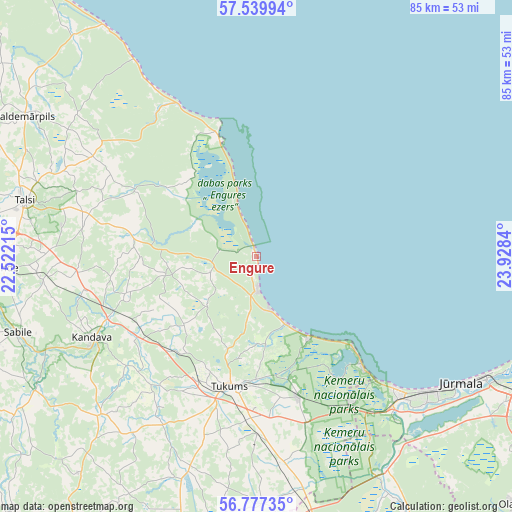
Engure GPS coordinates[2]
57° 9' 38.196" North, 23° 13' 30.972" East
| Map corner | latitude | longitude |
|---|---|---|
| Upper-left | 57.53994°, | 22.52215° |
| Center: | 57.16061°, | 23.22527° |
| Lower-right: | 56.77735°, | 23.9284° |
| Map W x H: | 84.8×84.8 km | = 52.7×52.7mi |
| max Lat: | 57.89752° ⇑25.7% North |
| Engure: | 57.16061° |
| min Lat: | ⇓74.3% South 55.75284° |
| min Long | Engure | max Long |
| 21.01085° | 23.22527° | 28.12165° |
| W 20.7%⇐ | ⇒79.3% E |
Elevation
Elevation of Engure is 6 m = 20 ft, and this is 59.4 m = 195 ft below average elevation for this country.
| Max E: |
212 m = 696 ft | 93.6% |
| Avg. | 65.4 m = 215 ft | |
| Engure | 6 m = 20 ft | |
Min E: |
2 m = 7 ft | 6.4% |
See also: Latvia elevation on elevation.city.
Geographical zone
Engure is located in North temperate zone (between Tropic of Cancer and the Arctic Circle). Distance of this North polar circle is 1045.5 km =649.6 mi to North.| Distance of | km | miles | from Engure |
|---|---|---|---|
| North Pole | 3651.4 | 2268.9 | to North |
| Arctic Circle | 1045.5 | 649.6 | to North |
| Tropic Cancer | 3749.7 | 2330 | to South |
| Equator | 6355.7 | 3949.2 | to South |


Nearby cities:
15 places around Engure: (largest is in red/bold)
• Jaunpils
49.4 km =30.7 mi,  195°
195°
• Jūrmala
39.3 km =24.4 mi,  123°
123°
• Kandava
30.3 km =18.8 mi,  243°
243°
• Milzkalne
20.4 km =12.7 mi,  179°
179°
• Mērsrags
20.4 km =12.7 mi,  342°
342°
• Piņķi
48.2 km =30 mi, 120°
• Ragaciems
22.4 km =13.9 mi,  133°
133°
• Roja
45.4 km =28.2 mi,  326°
326°
• Sabile
41.4 km =25.7 mi,  252°
252°
• Smārde
23.9 km =14.9 mi,  163°
163°
• Stende
41.7 km =25.9 mi,  267°
267°
• Talsi
39.9 km =24.8 mi,  283°
283°
• Tukums
21.9 km =13.6 mi,  191°
191°
• Tīreļi
41.9 km =26 mi,  148°
148°
• Valdemārpils
44.7 km =27.8 mi,  301°
301°
Sources, notices
• [Note1] Compared only with cities in Latvia existing in our database
• [Src1] Map data: © OpenStreetMap contributors (CC-BY-SA)
• [Src2] Other city data from geonames.org with taken over terms of usage.
• [Src3] Geographical zone / Annual Mean Temperature by Robert A. Rohde @ Wikipedia
