Valmiera geodata
Valmiera is a seat of a first-order administrative division; located in Latvia in Europe/Riga (GMT+3) time zone. With population of 26,963 people, there are 8 cities with bigger population in this country. Compared to other cities in Latvia, 92.1% of cities are located further ↓South; 67.1% of cities are located further ←West and 64.3% of cities have higher elevation than Valmiera. Note1


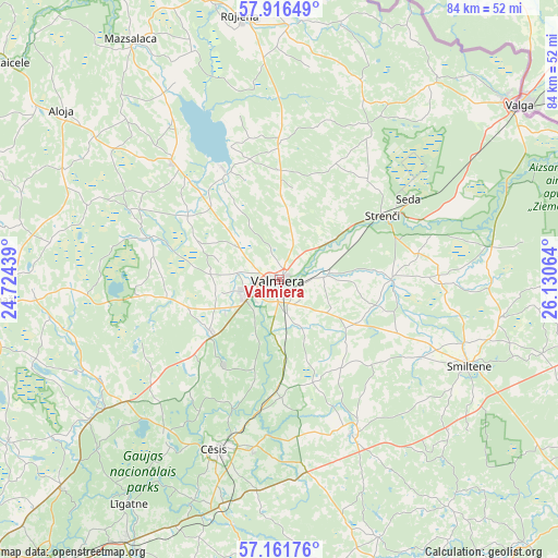
Valmiera GPS coordinates[2]
57° 32' 27.888" North, 25° 25' 39.036" East
| Map corner | latitude | longitude |
|---|---|---|
| Upper-left | 57.91649°, | 24.72439° |
| Center: | 57.54108°, | 25.42751° |
| Lower-right: | 57.16176°, | 26.13064° |
| Map W x H: | 83.9×83.9 km | = 52.1×52.1mi |
| max Lat: | 57.89752° ⇑7.9% North |
| Valmiera: | 57.54108° |
| min Lat: | ⇓92.1% South 55.75284° |
| min Long | Valmiera | max Long |
| 21.01085° | 25.42751° | 28.12165° |
| W 67.1%⇐ | ⇒32.9% E |
Elevation
Elevation of Valmiera is 43 m = 141 ft, and this is 22.4 m = 73 ft below average elevation for this country.
| Max E: |
212 m = 696 ft | 64.3% |
| Avg. | 65.4 m = 215 ft | |
| Valmiera | 43 m = 141 ft | |
Min E: |
2 m = 7 ft | 35.7% |
See also: Latvia elevation on elevation.city.
Geographical zone
Valmiera is located in North temperate zone (between Tropic of Cancer and the Arctic Circle). Distance of this North polar circle is 1003.2 km =623.4 mi to North.| Distance of | km | miles | from Valmiera |
|---|---|---|---|
| North Pole | 3609.1 | 2242.6 | to North |
| Arctic Circle | 1003.2 | 623.4 | to North |
| Tropic Cancer | 3792 | 2356.2 | to South |
| Equator | 6398 | 3975.5 | to South |


Nearby cities:
15 places around Valmiera: (largest is in red/bold)
• Aloja
41.3 km =25.7 mi,  307°
307°
• Cēsis
27.1 km =16.8 mi,  199°
199°
• Drabeši
34.3 km =21.3 mi, 195°
• Kocēni
5.8 km =3.6 mi,  246°
246°
• Līgatne
41.2 km =25.6 mi,  214°
214°
• Matīši
23.7 km =14.7 mi,  317°
317°
• Mūrmuiža
8.5 km =5.3 mi,  153°
153°
• Naukšēni
38.1 km =23.7 mi,  2°
2°
• Priekuļi
25.4 km =15.8 mi,  188°
188°
• Rauna
25.7 km =16 mi, 154°
• Rūjiena
40 km =24.9 mi,  351°
351°
• Seda
22.8 km =14.2 mi,  57°
57°
• Smiltene
31.2 km =19.4 mi,  114°
114°
• Stalbe
30.4 km =18.9 mi,  231°
231°
• Strenči
18 km =11.2 mi, 58°
Sources, notices
• [Note1] Compared only with cities in Latvia existing in our database
• [Src1] Map data: © OpenStreetMap contributors (CC-BY-SA)
• [Src2] Other city data from geonames.org with taken over terms of usage.
• [Src3] Geographical zone / Annual Mean Temperature by Robert A. Rohde @ Wikipedia
