Lubāna geodata
Lubāna is a seat of a first-order administrative division; located in Latvia in Europe/Riga (GMT+3) time zone. With population of 1,918 people, there are 77 cities with bigger population in this country. Compared to other cities in Latvia, 51.4% of cities are located further ↑North; 85.7% of cities are located further ←West and 72.9% of cities have lower elevation than Lubāna. Note1


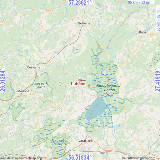
Lubāna GPS coordinates[2]
56° 54' 15.3" North, 26° 42' 57.816" East
| Map corner | latitude | longitude |
|---|---|---|
| Upper-left | 57.28621°, | 26.01294° |
| Center: | 56.90425°, | 26.71606° |
| Lower-right: | 56.51834°, | 27.41919° |
| Map W x H: | 85.4×85.4 km | = 53.1×53.1mi |
| max Lat: | 57.89752° ⇑51.4% North |
| Lubāna: | 56.90425° |
| min Lat: | ⇓48.6% South 55.75284° |
| min Long | Lubāna | max Long |
| 21.01085° | 26.71606° | 28.12165° |
| W 85.7%⇐ | ⇒14.3% E |
Elevation
Elevation of Lubāna is 95 m = 312 ft, and this is 29.6 m = 97 ft above average elevation for this country.
| Max E: |
212 m = 696 ft | 27.1% |
| Lubāna | 95 m 312 ft | |
| Avg. | 65.4 m = 215 ft | |
Min E: |
2 m = 7 ft | 72.9% |
See also: Latvia elevation on elevation.city.
Geographical zone
Lubāna is located in North temperate zone (between Tropic of Cancer and the Arctic Circle). Distance of this North polar circle is 1074 km =667.4 mi to North.| Distance of | km | miles | from Lubāna |
|---|---|---|---|
| North Pole | 3679.9 | 2286.6 | to North |
| Arctic Circle | 1074 | 667.4 | to North |
| Tropic Cancer | 3721.2 | 2312.2 | to South |
| Equator | 6327.2 | 3931.5 | to South |


Nearby cities:
15 places around Lubāna: (largest is in red/bold)
• Alūksne
60.9 km =37.8 mi,  19°
19°
• Baltinava
56.5 km =35.1 mi,  85°
85°
• Balvi
41.8 km =26 mi,  52°
52°
• Cesvaine
25.8 km =16 mi,  285°
285°
• Gulbene
30.5 km =19 mi,  4°
4°
• Jaunpiebalga
51.5 km =32 mi,  306°
306°
• Kārsava
60.6 km =37.7 mi,  102°
102°
• Madona
30.8 km =19.1 mi,  259°
259°
• Riebiņi
62.6 km =38.9 mi,  175°
175°
• Rugāji
27.6 km =17.1 mi,  66°
66°
• Rēzekne
58 km =36 mi,  138°
138°
• Varakļāni
33 km =20.5 mi, 176°
• Vecpiebalga
57.2 km =35.5 mi, 287°
• Viļāni
41.1 km =25.5 mi,  161°
161°
• Ērgļi
65.5 km =40.7 mi,  269°
269°
Sources, notices
• [Note1] Compared only with cities in Latvia existing in our database
• [Src1] Map data: © OpenStreetMap contributors (CC-BY-SA)
• [Src2] Other city data from geonames.org with taken over terms of usage.
• [Src3] Geographical zone / Annual Mean Temperature by Robert A. Rohde @ Wikipedia
