Jaunpiebalga geodata
Jaunpiebalga is a seat of a first-order administrative division; located in Latvia in Europe/Riga (GMT+3) time zone. In our database, there are 110 cities with bigger population. Compared to other cities in Latvia, 75% of cities are located further ↓South; 80% of cities are located further ←West and 95.7% of cities have lower elevation than Jaunpiebalga. Note1


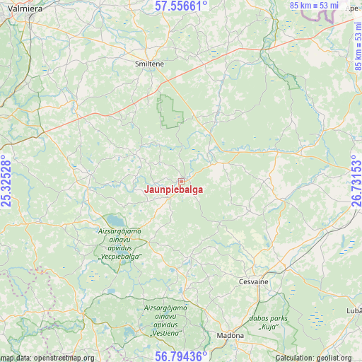
Jaunpiebalga GPS coordinates[2]
57° 10' 38.82" North, 26° 1' 42.24" East
| Map corner | latitude | longitude |
|---|---|---|
| Upper-left | 57.55661°, | 25.32528° |
| Center: | 57.17745°, | 26.0284° |
| Lower-right: | 56.79436°, | 26.73153° |
| Map W x H: | 84.8×84.8 km | = 52.7×52.7mi |
| max Lat: | 57.89752° ⇑25% North |
| Jaunpiebalga: | 57.17745° |
| min Lat: | ⇓75% South 55.75284° |
| min Long | Jaunpiebalga | max Long |
| 21.01085° | 26.0284° | 28.12165° |
| W 80%⇐ | ⇒20% E |
Elevation
Elevation of Jaunpiebalga is 161 m = 528 ft, and this is 95.6 m = 314 ft above average elevation for this country.
| Max E: |
212 m = 696 ft | 4.3% |
| Jaunpiebalga | 161 m 528 ft | |
| Avg. | 65.4 m = 215 ft | |
Min E: |
2 m = 7 ft | 95.7% |
See also: Latvia elevation on elevation.city.
Geographical zone
Jaunpiebalga is located in North temperate zone (between Tropic of Cancer and the Arctic Circle). Distance of this North polar circle is 1043.6 km =648.5 mi to North.| Distance of | km | miles | from Jaunpiebalga |
|---|---|---|---|
| North Pole | 3649.5 | 2267.7 | to North |
| Arctic Circle | 1043.6 | 648.5 | to North |
| Tropic Cancer | 3751.6 | 2331.1 | to South |
| Equator | 6357.5 | 3950.4 | to South |


Nearby cities:
15 places around Jaunpiebalga: (largest is in red/bold)
• Cesvaine
28.8 km =17.9 mi,  144°
144°
• Cēsis
47.8 km =29.7 mi,  288°
288°
• Drabeši
45.8 km =28.5 mi,  279°
279°
• Gulbene
43.7 km =27.2 mi,  89°
89°
• Lubāna
51.5 km =32 mi,  126°
126°
• Madona
37.8 km =23.5 mi,  162°
162°
• Mūrmuiža
46 km =28.6 mi,  315°
315°
• Priekuļi
42.9 km =26.7 mi, 290°
• Rauna
30.5 km =19 mi,  304°
304°
• Seda
55.2 km =34.3 mi,  342°
342°
• Smiltene
28.5 km =17.7 mi, 344°
• Strenči
53.9 km =33.5 mi, 337°
• Valmiera
54.2 km =33.7 mi, 318°
• Vecpiebalga
18.2 km =11.3 mi,  224°
224°
• Ērgļi
39.1 km =24.3 mi, 217°
Sources, notices
• [Note1] Compared only with cities in Latvia existing in our database
• [Src1] Map data: © OpenStreetMap contributors (CC-BY-SA)
• [Src2] Other city data from geonames.org with taken over terms of usage.
• [Src3] Geographical zone / Annual Mean Temperature by Robert A. Rohde @ Wikipedia
