Alūksne geodata
Alūksne (Alūksnes Novads) is a seat of a first-order administrative division; located in Latvia in Europe/Riga (GMT+3) time zone. With population of 2,264 people, there are 66 cities with bigger population in this country. Compared to other cities in Latvia, 86.4% of cities are located further ↓South; 92.1% of cities are located further ←West and 99.3% of cities have lower elevation than Alūksne. Note1


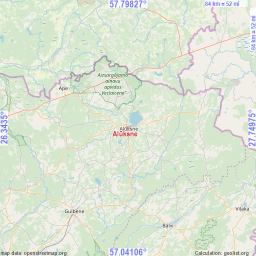
Alūksne GPS coordinates[2]
57° 25' 17.832" North, 27° 2' 47.832" East
| Map corner | latitude | longitude |
|---|---|---|
| Upper-left | 57.79827°, | 26.3435° |
| Center: | 57.42162°, | 27.04662° |
| Lower-right: | 57.04106°, | 27.74975° |
| Map W x H: | 84.2×84.2 km | = 52.3×52.3mi |
| max Lat: | 57.89752° ⇑13.6% North |
| Alūksne: | 57.42162° |
| min Lat: | ⇓86.4% South 55.75284° |
| min Long | Alūksne | max Long |
| 21.01085° | 27.04662° | 28.12165° |
| W 92.1%⇐ | ⇒7.9% E |
Elevation
Elevation of Alūksne is 193 m = 633 ft, and this is 127.6 m = 419 ft above average elevation for this country.
| Max E: |
212 m = 696 ft | 0.7% |
| Alūksne | 193 m 633 ft | |
| Avg. | 65.4 m = 215 ft | |
Min E: |
2 m = 7 ft | 99.3% |
See also: Latvia elevation on elevation.city.
Geographical zone
Alūksne is located in North temperate zone (between Tropic of Cancer and the Arctic Circle). Distance of this North polar circle is 1016.5 km =631.6 mi to North.| Distance of | km | miles | from Alūksne |
|---|---|---|---|
| North Pole | 3622.4 | 2250.9 | to North |
| Arctic Circle | 1016.5 | 631.6 | to North |
| Tropic Cancer | 3778.8 | 2348 | to South |
| Equator | 6384.7 | 3967.3 | to South |


Nearby cities:
15 places around Alūksne: (largest is in red/bold)
• Ape
24.9 km =15.5 mi,  301°
301°
• Baltinava
64.2 km =39.9 mi,  145°
145°
• Balvi
34.9 km =21.7 mi,  157°
157°
• Cesvaine
67.3 km =41.8 mi,  221°
221°
• Gulbene
32.4 km =20.1 mi,  213°
213°
• Jaunpiebalga
66.9 km =41.6 mi,  246°
246°
• Kārsava
80.8 km =50.2 mi, 151°
• Lubāna
60.9 km =37.8 mi,  199°
199°
• Madona
80.6 km =50.1 mi, 218°
• Rugāji
46.8 km =29.1 mi,  173°
173°
• Seda
81.4 km =50.6 mi,  288°
288°
• Smiltene
68.5 km =42.6 mi,  270°
270°
• Valka
73.2 km =45.5 mi, 302°
• Vecpiebalga
84.2 km =52.3 mi,  241°
241°
• Viļaka
45.9 km =28.5 mi,  125°
125°
Sources, notices
• [Note1] Compared only with cities in Latvia existing in our database
• [Src1] Map data: © OpenStreetMap contributors (CC-BY-SA)
• [Src2] Other city data from geonames.org with taken over terms of usage.
• [Src3] Geographical zone / Annual Mean Temperature by Robert A. Rohde @ Wikipedia
