Baltinava geodata
Baltinava is a seat of a first-order administrative division; located in Latvia in Europe/Riga (GMT+3) time zone. In our database, there are 110 cities with bigger population. Compared to other cities in Latvia, 51.4% of cities are located further ↓South; 96.4% of cities are located further ←West and 74.3% of cities have lower elevation than Baltinava. Note1


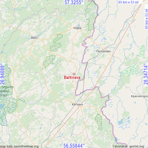
Baltinava GPS coordinates[2]
56° 56' 38.184" North, 27° 38' 38.436" East
| Map corner | latitude | longitude |
|---|---|---|
| Upper-left | 57.3255°, | 26.94089° |
| Center: | 56.94394°, | 27.64401° |
| Lower-right: | 56.55844°, | 28.34714° |
| Map W x H: | 85.3×85.3 km | = 53×53mi |
| max Lat: | 57.89752° ⇑48.6% North |
| Baltinava: | 56.94394° |
| min Lat: | ⇓51.4% South 55.75284° |
| min Long | Baltinava | max Long |
| 21.01085° | 27.64401° | 28.12165° |
| W 96.4%⇐ | ⇒3.6% E |
Elevation
Elevation of Baltinava is 98 m = 322 ft, and this is 32.6 m = 107 ft above average elevation for this country.
| Max E: |
212 m = 696 ft | 25.7% |
| Baltinava | 98 m 322 ft | |
| Avg. | 65.4 m = 215 ft | |
Min E: |
2 m = 7 ft | 74.3% |
See also: Latvia elevation on elevation.city.
Geographical zone
Baltinava is located in North temperate zone (between Tropic of Cancer and the Arctic Circle). Distance of this North polar circle is 1069.6 km =664.6 mi to North.| Distance of | km | miles | from Baltinava |
|---|---|---|---|
| North Pole | 3675.5 | 2283.8 | to North |
| Arctic Circle | 1069.6 | 664.6 | to North |
| Tropic Cancer | 3725.7 | 2315 | to South |
| Equator | 6331.6 | 3934.3 | to South |


Nearby cities:
15 places around Baltinava: (largest is in red/bold)
• Alūksne
64.2 km =39.9 mi,  325°
325°
• Balvi
30.9 km =19.2 mi,  312°
312°
• Cesvaine
81.1 km =50.4 mi,  271°
271°
• Cibla
46.2 km =28.7 mi,  161°
161°
• Gulbene
59.8 km =37.2 mi,  295°
295°
• Kārsava
18 km =11.2 mi,  171°
171°
• Lubāna
56.5 km =35.1 mi, 265°
• Ludza
45.2 km =28.1 mi, 174°
• Riebiņi
84.4 km =52.4 mi,  217°
217°
• Rugāji
31.6 km =19.6 mi,  282°
282°
• Rēzekne
51.7 km =32.1 mi,  201°
201°
• Varakļāni
65.8 km =40.9 mi,  235°
235°
• Viļaka
26.8 km =16.7 mi,  3°
3°
• Viļāni
61.8 km =38.4 mi,  225°
225°
• Zilupe
68.5 km =42.6 mi,  154°
154°
Sources, notices
• [Note1] Compared only with cities in Latvia existing in our database
• [Src1] Map data: © OpenStreetMap contributors (CC-BY-SA)
• [Src2] Other city data from geonames.org with taken over terms of usage.
• [Src3] Geographical zone / Annual Mean Temperature by Robert A. Rohde @ Wikipedia
