Cesvaine geodata
Cesvaine is a seat of a first-order administrative division; located in Latvia in Europe/Riga (GMT+3) time zone. With population of 1,811 people, there are 80 cities with bigger population in this country. Compared to other cities in Latvia, 53.6% of cities are located further ↓South; 82.9% of cities are located further ←West and 97.1% of cities have lower elevation than Cesvaine. Note1


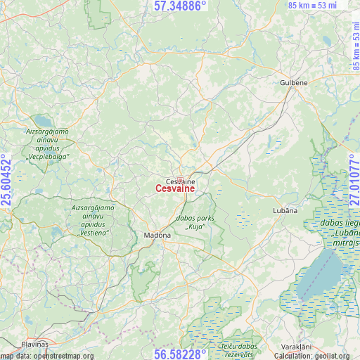
Cesvaine GPS coordinates[2]
56° 58' 3.144" North, 26° 18' 27.504" East
| Map corner | latitude | longitude |
|---|---|---|
| Upper-left | 57.34886°, | 25.60452° |
| Center: | 56.96754°, | 26.30764° |
| Lower-right: | 56.58228°, | 27.01077° |
| Map W x H: | 85.2×85.2 km | = 52.9×52.9mi |
| max Lat: | 57.89752° ⇑46.4% North |
| Cesvaine: | 56.96754° |
| min Lat: | ⇓53.6% South 55.75284° |
| min Long | Cesvaine | max Long |
| 21.01085° | 26.30764° | 28.12165° |
| W 82.9%⇐ | ⇒17.1% E |
Elevation
Elevation of Cesvaine is 166 m = 545 ft, and this is 100.6 m = 330 ft above average elevation for this country.
| Max E: |
212 m = 696 ft | 2.9% |
| Cesvaine | 166 m 545 ft | |
| Avg. | 65.4 m = 215 ft | |
Min E: |
2 m = 7 ft | 97.1% |
See also: Latvia elevation on elevation.city.
Geographical zone
Cesvaine is located in North temperate zone (between Tropic of Cancer and the Arctic Circle). Distance of this North polar circle is 1067 km =663 mi to North.| Distance of | km | miles | from Cesvaine |
|---|---|---|---|
| North Pole | 3672.9 | 2282.2 | to North |
| Arctic Circle | 1067 | 663 | to North |
| Tropic Cancer | 3728.3 | 2316.7 | to South |
| Equator | 6334.2 | 3935.9 | to South |


Nearby cities:
15 places around Cesvaine: (largest is in red/bold)
• Balvi
60.7 km =37.7 mi,  72°
72°
• Gulbene
35.6 km =22.1 mi,  49°
49°
• Jaunpiebalga
28.8 km =17.9 mi,  324°
324°
• Jēkabpils
58.9 km =36.6 mi,  207°
207°
• Krustpils
57.6 km =35.8 mi, 208°
• Lubāna
25.8 km =16 mi,  105°
105°
• Madona
13.8 km =8.6 mi,  203°
203°
• Pļaviņas
52.6 km =32.7 mi,  222°
222°
• Rauna
58.4 km =36.3 mi,  313°
313°
• Rugāji
50.2 km =31.2 mi,  85°
85°
• Smiltene
56.4 km =35 mi,  334°
334°
• Varakļāni
48.3 km =30 mi,  145°
145°
• Vecpiebalga
31.5 km =19.6 mi,  289°
289°
• Viļāni
59.5 km =37 mi,  140°
140°
• Ērgļi
41.4 km =25.7 mi,  259°
259°
Sources, notices
• [Note1] Compared only with cities in Latvia existing in our database
• [Src1] Map data: © OpenStreetMap contributors (CC-BY-SA)
• [Src2] Other city data from geonames.org with taken over terms of usage.
• [Src3] Geographical zone / Annual Mean Temperature by Robert A. Rohde @ Wikipedia
