Zilupe geodata
Zilupe (Zilupes) is a seat of a first-order administrative division; located in Latvia in Europe/Riga (GMT+3) time zone. With population of 1,897 people, there are 78 cities with bigger population in this country. Compared to other cities in Latvia, 87.9% of cities are located further ↑North; 100% of cities are located further ←West and 87.1% of cities have lower elevation than Zilupe. Note1


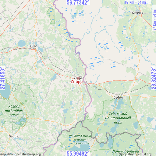
Zilupe GPS coordinates[2]
56° 23' 10.176" North, 28° 7' 17.94" East
| Map corner | latitude | longitude |
|---|---|---|
| Upper-left | 56.77342°, | 27.41853° |
| Center: | 56.38616°, | 28.12165° |
| Lower-right: | 55.99492°, | 28.82478° |
| Map W x H: | 86.6×86.6 km | = 53.8×53.8mi |
| max Lat: | 57.89752° ⇑87.9% North |
| Zilupe: | 56.38616° |
| min Lat: | ⇓12.1% South 55.75284° |
| min Long | Zilupe | max Long |
| 21.01085° | 28.12165° | 28.12165° |
| W 100%⇐ | ⇒0% E |
Elevation
Elevation of Zilupe is 124 m = 407 ft, and this is 58.6 m = 192 ft above average elevation for this country.
| Max E: |
212 m = 696 ft | 12.9% |
| Zilupe | 124 m 407 ft | |
| Avg. | 65.4 m = 215 ft | |
Min E: |
2 m = 7 ft | 87.1% |
See also: Latvia elevation on elevation.city.
Geographical zone
Zilupe is located in North temperate zone (between Tropic of Cancer and the Arctic Circle). Distance of this North polar circle is 1131.6 km =703.1 mi to North.| Distance of | km | miles | from Zilupe |
|---|---|---|---|
| North Pole | 3737.5 | 2322.4 | to North |
| Arctic Circle | 1131.6 | 703.1 | to North |
| Tropic Cancer | 3663.6 | 2276.5 | to South |
| Equator | 6269.6 | 3895.7 | to South |


Nearby cities:
15 places around Zilupe: (largest is in red/bold)
• Aglona
74.4 km =46.2 mi,  247°
247°
• Baltinava
68.5 km =42.6 mi,  334°
334°
• Cibla
23.3 km =14.5 mi,  321°
321°
• Dagda
48.5 km =30.1 mi,  228°
228°
• Jaunaglona
73.2 km =45.5 mi, 249°
• Krāslava
80.4 km =50 mi, 227°
• Kārsava
51.6 km =32.1 mi, 329°
• Ludza
30.1 km =18.7 mi,  304°
304°
• Preiļi
86.7 km =53.9 mi,  263°
263°
• Riebiņi
81.5 km =50.6 mi,  266°
266°
• Rugāji
91.4 km =56.8 mi, 318°
• Rēzekne
50 km =31.1 mi,  286°
286°
• Varakļāni
87.5 km =54.4 mi, 286°
• Viļaka
92.9 km =57.7 mi,  342°
342°
• Viļāni
75.8 km =47.1 mi,  284°
284°
Sources, notices
• [Note1] Compared only with cities in Latvia existing in our database
• [Src1] Map data: © OpenStreetMap contributors (CC-BY-SA)
• [Src2] Other city data from geonames.org with taken over terms of usage.
• [Src3] Geographical zone / Annual Mean Temperature by Robert A. Rohde @ Wikipedia
