Ludza geodata
Ludza (Ludzas novads) is a seat of a first-order administrative division; located in Latvia in Europe/Riga (GMT+3) time zone. With population of 10,514 people, there are 21 cities with bigger population in this country. Compared to other cities in Latvia, 77.1% of cities are located further ↑North; 98.6% of cities are located further ←West and 91.4% of cities have lower elevation than Ludza. Note1


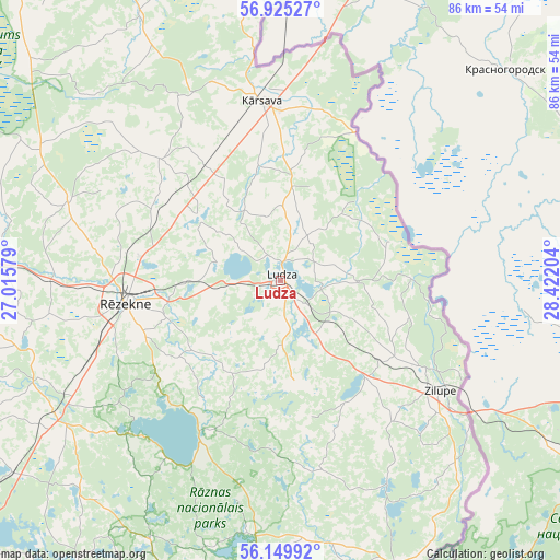
Ludza GPS coordinates[2]
56° 32' 22.488" North, 27° 43' 8.076" East
| Map corner | latitude | longitude |
|---|---|---|
| Upper-left | 56.92527°, | 27.01579° |
| Center: | 56.53958°, | 27.71891° |
| Lower-right: | 56.14992°, | 28.42204° |
| Map W x H: | 86.2×86.2 km | = 53.6×53.6mi |
| max Lat: | 57.89752° ⇑77.1% North |
| Ludza: | 56.53958° |
| min Lat: | ⇓22.9% South 55.75284° |
| min Long | Ludza | max Long |
| 21.01085° | 27.71891° | 28.12165° |
| W 98.6%⇐ | ⇒1.4% E |
Elevation
Elevation of Ludza is 147 m = 482 ft, and this is 81.6 m = 268 ft above average elevation for this country.
| Max E: |
212 m = 696 ft | 8.6% |
| Ludza | 147 m 482 ft | |
| Avg. | 65.4 m = 215 ft | |
Min E: |
2 m = 7 ft | 91.4% |
See also: Latvia elevation on elevation.city.
Geographical zone
Ludza is located in North temperate zone (between Tropic of Cancer and the Arctic Circle). Distance of this North polar circle is 1114.6 km =692.6 mi to North.| Distance of | km | miles | from Ludza |
|---|---|---|---|
| North Pole | 3720.4 | 2311.7 | to North |
| Arctic Circle | 1114.6 | 692.6 | to North |
| Tropic Cancer | 3680.7 | 2287.1 | to South |
| Equator | 6286.6 | 3906.3 | to South |


Nearby cities:
15 places around Ludza: (largest is in red/bold)
• Aglona
63 km =39.1 mi,  224°
224°
• Baltinava
45.2 km =28.1 mi,  354°
354°
• Balvi
71.3 km =44.3 mi,  337°
337°
• Cibla
10.2 km =6.3 mi,  83°
83°
• Dagda
50.7 km =31.5 mi,  192°
192°
• Jaunaglona
60.8 km =37.8 mi,  226°
226°
• Kārsava
27.2 km =16.9 mi,  356°
356°
• Preiļi
67 km =41.6 mi,  245°
245°
• Riebiņi
60.6 km =37.7 mi, 248°
• Rugāji
62.7 km =39 mi,  325°
325°
• Rēzekne
23.5 km =14.6 mi,  262°
262°
• Varakļāni
59.6 km =37 mi,  277°
277°
• Viļaka
71.8 km =44.6 mi, 357°
• Viļāni
48.7 km =30.3 mi,  271°
271°
• Zilupe
30.1 km =18.7 mi,  124°
124°
Sources, notices
• [Note1] Compared only with cities in Latvia existing in our database
• [Src1] Map data: © OpenStreetMap contributors (CC-BY-SA)
• [Src2] Other city data from geonames.org with taken over terms of usage.
• [Src3] Geographical zone / Annual Mean Temperature by Robert A. Rohde @ Wikipedia
