Ouijjane geodata
Ouijjane (Souss-Massa) is a seat of a third-order administrative division; located in Morocco in Africa/Casablanca (GMT+1) time zone. In our database, there are 108 cities with bigger population. Compared to other cities in Morocco, 96.1% of cities are located further ↑North; 93% of cities are located further →East and 63.2% of cities have higher elevation than Ouijjane. Note1


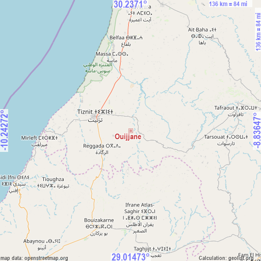
Ouijjane GPS coordinates[2]
29° 37' 39.972" North, 9° 32' 22.524" West
| Map corner | latitude | longitude |
|---|---|---|
| Upper-left | 30.2371°, | -10.24272° |
| Center: | 29.62777°, | -9.53959° |
| Lower-right: | 29.01473°, | -8.83647° |
| Map W x H: | 135.9×135.9 km | = 84.4×84.4mi |
| max Lat: | 35.84906° ⇑96.1% North |
| Ouijjane: | 29.62777° |
| min Lat: | ⇓3.9% South 22.6558° |
| min Long | Ouijjane | max Long |
| -15.60719° | -9.53959° | -1.22855° |
| W 7%⇐ | ⇒93% E |
Elevation
Elevation of Ouijjane is 306 m = 1004 ft, and this is 310.8 m = 1020 ft below average elevation for this country.
| Max E: |
2637 m = 8652 ft | 63.2% |
| Avg. | 616.8 m = 2024 ft | |
| Ouijjane | 306 m = 1004 ft | |
Min E: |
1 m = 3 ft | 36.8% |
See also: Morocco elevation on elevation.city.
Geographical zone
Ouijjane is located in North temperate zone (between Tropic of Cancer and the Arctic Circle). Distance of this Northern Tropic circle is 688.4 km =427.8 mi to South.| Distance of | km | miles | from Ouijjane |
|---|---|---|---|
| North Pole | 6712.8 | 4171.1 | to North |
| Arctic Circle | 4106.9 | 2551.9 | to North |
| Tropic Cancer | 688.4 | 427.8 | to South |
| Equator | 3294.3 | 2047 | to South |


Nearby cities:
15 places around Ouijjane: (largest is in red/bold)
• Agadir
88.3 km =54.9 mi,  356°
356°
• Amalou
98.7 km =61.3 mi,  50°
50°
• Aourir
96.6 km =60 mi,  354°
354°
• Assads
93.7 km =58.2 mi,  44°
44°
• Dakhla
87.1 km =54.1 mi, 358°
• Guelmim
87.2 km =54.2 mi,  215°
215°
• Inezgane
80.9 km =50.3 mi,  0°
0°
• Oulad Teïma
91 km =56.5 mi,  20°
20°
• Reggada
16.5 km =10.3 mi,  251°
251°
• Sidi Ifni
67.2 km =41.8 mi, 245°
• Tabia
78.3 km =48.7 mi, 54°
• Tafraout
55.6 km =34.5 mi,  78°
78°
• Tanalt
39.5 km =24.5 mi,  65°
65°
• Tarsouat
49.9 km =31 mi,  95°
95°
• Tiznit
20.1 km =12.5 mi,  292°
292°
Sources, notices
• [Note1] Compared only with cities in Morocco existing in our database
• [Src1] Map data: © OpenStreetMap contributors (CC-BY-SA)
• [Src2] Other city data from geonames.org with taken over terms of usage.
• [Src3] Geographical zone / Annual Mean Temperature by Robert A. Rohde @ Wikipedia
