Inezgane geodata
Inezgane (Souss-Massa) is a seat of a third-order administrative division; located in Morocco in Africa/Casablanca (GMT+1) time zone. In our database, there are 108 cities with bigger population. Compared to other cities in Morocco, 91.5% of cities are located further ↑North; 92.6% of cities are located further →East and 88.8% of cities have higher elevation than Inezgane. Note1


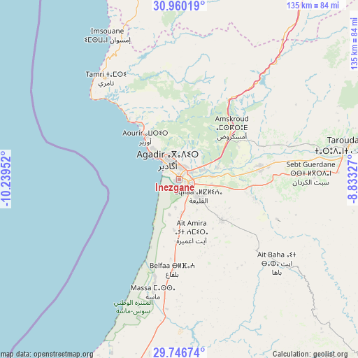
Inezgane GPS coordinates[2]
30° 21' 19.26" North, 9° 32' 11.004" West
| Map corner | latitude | longitude |
|---|---|---|
| Upper-left | 30.96019°, | -10.23952° |
| Center: | 30.35535°, | -9.53639° |
| Lower-right: | 29.74674°, | -8.83327° |
| Map W x H: | 134.9×134.9 km | = 83.8×83.8mi |
| max Lat: | 35.84906° ⇑91.5% North |
| Inezgane: | 30.35535° |
| min Lat: | ⇓8.5% South 22.6558° |
| min Long | Inezgane | max Long |
| -15.60719° | -9.53639° | -1.22855° |
| W 7.4%⇐ | ⇒92.6% E |
Elevation
Elevation of Inezgane is 31 m = 102 ft, and this is 585.8 m = 1922 ft below average elevation for this country.
| Max E: |
2637 m = 8652 ft | 88.8% |
| Avg. | 616.8 m = 2024 ft | |
| Inezgane | 31 m = 102 ft | |
Min E: |
1 m = 3 ft | 11.2% |
See also: Morocco elevation on elevation.city.
Geographical zone
Inezgane is located in North temperate zone (between Tropic of Cancer and the Arctic Circle). Distance of this Northern Tropic circle is 769.3 km =478 mi to South.| Distance of | km | miles | from Inezgane |
|---|---|---|---|
| North Pole | 6631.9 | 4120.9 | to North |
| Arctic Circle | 4026 | 2501.6 | to North |
| Tropic Cancer | 769.3 | 478 | to South |
| Equator | 3375.2 | 2097.3 | to South |


Nearby cities:
15 places around Inezgane: (largest is in red/bold)
• Agadir
9.3 km =5.8 mi,  320°
320°
• Aourir
18 km =11.2 mi,  328°
328°
• Argana
62 km =38.5 mi,  40°
40°
• Assads
66.4 km =41.3 mi,  102°
102°
• Bigoudine
51.5 km =32 mi, 37°
• Dakhla
6.4 km =4 mi,  343°
343°
• Oulad Teïma
31.7 km =19.7 mi,  82°
82°
• Tabia
72.7 km =45.2 mi,  119°
119°
• Tadrart
47.2 km =29.3 mi,  8°
8°
• Taghazout
26.7 km =16.6 mi, 321°
• Tamanar
73 km =45.4 mi,  349°
349°
• Tamri
47.2 km =29.3 mi, 323°
• Tanalt
73.6 km =45.7 mi,  151°
151°
• Taroudant
64.5 km =40.1 mi, 78°
• Tazemmourt
68.1 km =42.3 mi,  85°
85°
Sources, notices
• [Note1] Compared only with cities in Morocco existing in our database
• [Src1] Map data: © OpenStreetMap contributors (CC-BY-SA)
• [Src2] Other city data from geonames.org with taken over terms of usage.
• [Src3] Geographical zone / Annual Mean Temperature by Robert A. Rohde @ Wikipedia
