Agadir geodata
Agadir (Souss-Massa) is a seat of a first-order administrative division; located in Morocco in Africa/Casablanca (GMT+1) time zone. With population of 698,310 people, there are 5 cities with bigger population in this country. Compared to other cities in Morocco, 89.5% of cities are located further ↑North; 93.8% of cities are located further →East and 88.8% of cities have higher elevation than Agadir. Note1


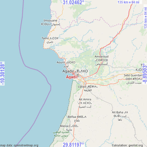
Agadir GPS coordinates[2]
30° 25' 12.648" North, 9° 35' 53.34" West
| Map corner | latitude | longitude |
|---|---|---|
| Upper-left | 31.02462°, | -10.30128° |
| Center: | 30.42018°, | -9.59815° |
| Lower-right: | 29.81197°, | -8.89503° |
| Map W x H: | 134.8×134.8 km | = 83.8×83.8mi |
| max Lat: | 35.84906° ⇑89.5% North |
| Agadir: | 30.42018° |
| min Lat: | ⇓10.5% South 22.6558° |
| min Long | Agadir | max Long |
| -15.60719° | -9.59815° | -1.22855° |
| W 6.2%⇐ | ⇒93.8% E |
Elevation
Elevation of Agadir is 31 m = 102 ft, and this is 585.8 m = 1922 ft below average elevation for this country.
| Max E: |
2637 m = 8652 ft | 88.8% |
| Avg. | 616.8 m = 2024 ft | |
| Agadir | 31 m = 102 ft | |
Min E: |
1 m = 3 ft | 11.2% |
See also: Agadir elevation on elevation.city.
Geographical zone
Agadir is located in North temperate zone (between Tropic of Cancer and the Arctic Circle). Distance of this Northern Tropic circle is 776.5 km =482.5 mi to South.| Distance of | km | miles | from Agadir |
|---|---|---|---|
| North Pole | 6624.7 | 4116.4 | to North |
| Arctic Circle | 4018.8 | 2497.2 | to North |
| Tropic Cancer | 776.5 | 482.5 | to South |
| Equator | 3382.4 | 2101.7 | to South |


Nearby cities:
15 places around Agadir: (largest is in red/bold)
• Aourir
8.8 km =5.5 mi,  335°
335°
• Argana
61 km =37.9 mi,  48°
48°
• Assads
73.9 km =45.9 mi,  106°
106°
• Bigoudine
50.1 km =31.1 mi, 47°
• Dakhla
4.2 km =2.6 mi,  104°
104°
• Inezgane
9.3 km =5.8 mi,  140°
140°
• Oulad Teïma
37.4 km =23.2 mi,  94°
94°
• Tadrart
41.6 km =25.8 mi,  18°
18°
• Taghazout
17.4 km =10.8 mi,  321°
321°
• Tamanar
65 km =40.4 mi,  353°
353°
• Tamri
37.8 km =23.5 mi, 324°
• Taroudant
69.4 km =43.1 mi, 85°
• Tazemmourt
73.8 km =45.9 mi, 91°
• Timezgadiouine
73.8 km =45.9 mi, 45°
• Tiznit
81.4 km =50.6 mi,  189°
189°
Sources, notices
• [Note1] Compared only with cities in Morocco existing in our database
• [Src1] Map data: © OpenStreetMap contributors (CC-BY-SA)
• [Src2] Other city data from geonames.org with taken over terms of usage.
• [Src3] Geographical zone / Annual Mean Temperature by Robert A. Rohde @ Wikipedia
