El Jadid geodata
El Jadid (Casablanca-Settat) is a populated place; located in Morocco in Africa/Casablanca (GMT+1) time zone. With population of 147,549 people, there are 18 cities with bigger population in this country. Compared to other cities in Morocco, 51.9% of cities are located further ↓South; 82.9% of cities are located further →East and 96.5% of cities have higher elevation than El Jadid. Note1


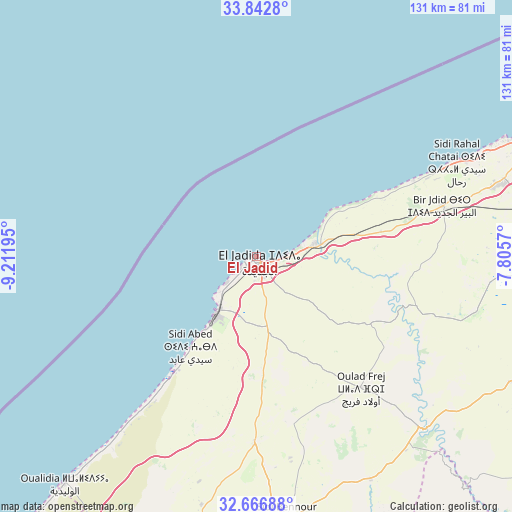
El Jadid GPS coordinates[2]
33° 15' 24.552" North, 8° 30' 31.752" West
| Map corner | latitude | longitude |
|---|---|---|
| Upper-left | 33.8428°, | -9.21195° |
| Center: | 33.25682°, | -8.50882° |
| Lower-right: | 32.66688°, | -7.8057° |
| Map W x H: | 130.8×130.8 km | = 81.3×81.3mi |
| max Lat: | 35.84906° ⇑48.1% North |
| El Jadid: | 33.25682° |
| min Lat: | ⇓51.9% South 22.6558° |
| min Long | El Jadid | max Long |
| -15.60719° | -8.50882° | -1.22855° |
| W 17.1%⇐ | ⇒82.9% E |
Elevation
Elevation of El Jadid is 10 m = 33 ft, and this is 606.8 m = 1991 ft below average elevation for this country.
| Max E: |
2637 m = 8652 ft | 96.5% |
| Avg. | 616.8 m = 2024 ft | |
| El Jadid | 10 m = 33 ft | |
Min E: |
1 m = 3 ft | 3.5% |
See also: El Jadid elevation on elevation.city.
Geographical zone
El Jadid is located in North temperate zone (between Tropic of Cancer and the Arctic Circle). Distance of this Northern Tropic circle is 1091.9 km =678.5 mi to South.| Distance of | km | miles | from El Jadid |
|---|---|---|---|
| North Pole | 6309.3 | 3920.4 | to North |
| Arctic Circle | 3703.4 | 2301.2 | to North |
| Tropic Cancer | 1091.9 | 678.5 | to South |
| Equator | 3697.8 | 2297.7 | to South |


Nearby cities:
15 places around El Jadid: (largest is in red/bold)
• Azemmour
15.9 km =9.9 mi,  76°
76°
• Berrechid
85.7 km =53.3 mi,  89°
89°
• Boulaouane
61.1 km =38 mi,  136°
136°
• Bouskoura
82.4 km =51.2 mi,  74°
74°
• Casablanca
91.1 km =56.6 mi, 66°
• Dar Bouazza
70.4 km =43.7 mi, 65°
• Mediouna
94.4 km =58.7 mi, 76°
• Moulay Abdallah
10 km =6.2 mi,  227°
227°
• Oualidia
75.8 km =47.1 mi,  219°
219°
• Oulad Frej
42.2 km =26.2 mi, 141°
• Settat
87.8 km =54.6 mi,  108°
108°
• Sidi Bennour
67.6 km =42 mi,  173°
173°
• Sidi Smai’il
48.1 km =29.9 mi,  180°
180°
• Tit Mellil
100.6 km =62.5 mi, 70°
• Zawyat an Nwaçer
83.8 km =52.1 mi, 80°
In other languages:
- In Spanish: El-Yadida
- In France: El Jadida
- In German: El Jadida
- In Russian: Эль-Джадида
- In Chinese: 杰迪代
Sources, notices
• [Note1] Compared only with cities in Morocco existing in our database
• [Src1] Map data: © OpenStreetMap contributors (CC-BY-SA)
• [Src2] Other city data from geonames.org with taken over terms of usage.
• [Src3] Geographical zone / Annual Mean Temperature by Robert A. Rohde @ Wikipedia
