Sidi Bennour geodata
Sidi Bennour (Casablanca-Settat) is a seat of a third-order administrative division; located in Morocco in Africa/Casablanca (GMT+1) time zone. With population of 40,044 people, there are 57 cities with bigger population in this country. Compared to other cities in Morocco, 57% of cities are located further ↑North; 82.2% of cities are located further →East and 73.6% of cities have higher elevation than Sidi Bennour. Note1


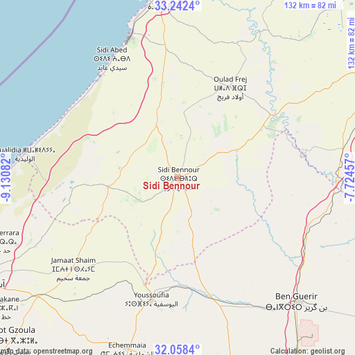
Sidi Bennour GPS coordinates[2]
32° 39' 8.496" North, 8° 25' 39.684" West
| Map corner | latitude | longitude |
|---|---|---|
| Upper-left | 33.2424°, | -9.13082° |
| Center: | 32.65236°, | -8.42769° |
| Lower-right: | 32.0584°, | -7.72457° |
| Map W x H: | 131.6×131.6 km | = 81.8×81.8mi |
| max Lat: | 35.84906° ⇑57% North |
| Sidi Bennour: | 32.65236° |
| min Lat: | ⇓43% South 22.6558° |
| min Long | Sidi Bennour | max Long |
| -15.60719° | -8.42769° | -1.22855° |
| W 17.8%⇐ | ⇒82.2% E |
Elevation
Elevation of Sidi Bennour is 182 m = 597 ft, and this is 434.8 m = 1427 ft below average elevation for this country.
| Max E: |
2637 m = 8652 ft | 73.6% |
| Avg. | 616.8 m = 2024 ft | |
| Sidi Bennour | 182 m = 597 ft | |
Min E: |
1 m = 3 ft | 26.4% |
See also: Sidi Bennour elevation on elevation.city.
Geographical zone
Sidi Bennour is located in North temperate zone (between Tropic of Cancer and the Arctic Circle). Distance of this Northern Tropic circle is 1024.7 km =636.7 mi to South.| Distance of | km | miles | from Sidi Bennour |
|---|---|---|---|
| North Pole | 6376.5 | 3962.2 | to North |
| Arctic Circle | 3770.6 | 2342.9 | to North |
| Tropic Cancer | 1024.7 | 636.7 | to South |
| Equator | 3630.6 | 2255.9 | to South |


Nearby cities:
15 places around Sidi Bennour: (largest is in red/bold)
• Azemmour
71.3 km =44.3 mi,  6°
6°
• Berrechid
103.9 km =64.6 mi,  48°
48°
• Boulaouane
41.8 km =26 mi,  56°
56°
• El Jadid
67.6 km =42 mi,  353°
353°
• Guisser
87.9 km =54.6 mi,  81°
81°
• Moulay Abdallah
62.3 km =38.7 mi, 346°
• Oualidia
57.1 km =35.5 mi,  279°
279°
• Oulad Frej
39 km =24.2 mi,  28°
28°
• Safi
85.5 km =53.1 mi,  242°
242°
• Settat
85.1 km =52.9 mi, 62°
• Sidi Abdallah
57.3 km =35.6 mi,  103°
103°
• Sidi Bou Othmane
95.1 km =59.1 mi,  151°
151°
• Sidi Smai’il
20.7 km =12.9 mi,  337°
337°
• Youssoufia
46.1 km =28.6 mi,  191°
191°
• Zawyat an Nwaçer
110.6 km =68.7 mi,  42°
42°
Sources, notices
• [Note1] Compared only with cities in Morocco existing in our database
• [Src1] Map data: © OpenStreetMap contributors (CC-BY-SA)
• [Src2] Other city data from geonames.org with taken over terms of usage.
• [Src3] Geographical zone / Annual Mean Temperature by Robert A. Rohde @ Wikipedia
