Boulaouane geodata
Boulaouane (Casablanca-Settat) is a seat of a third-order administrative division; located in Morocco in Africa/Casablanca (GMT+1) time zone. In our database, there are 108 cities with bigger population. Compared to other cities in Morocco, 53.5% of cities are located further ↑North; 78.7% of cities are located further →East and 74% of cities have higher elevation than Boulaouane. Note1


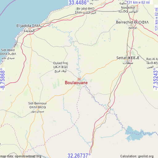
Boulaouane GPS coordinates[2]
32° 51' 35.82" North, 8° 3' 19.98" West
| Map corner | latitude | longitude |
|---|---|---|
| Upper-left | 33.4486°, | -8.75868° |
| Center: | 32.85995°, | -8.05555° |
| Lower-right: | 32.26737°, | -7.35243° |
| Map W x H: | 131.3×131.3 km | = 81.6×81.6mi |
| max Lat: | 35.84906° ⇑53.5% North |
| Boulaouane: | 32.85995° |
| min Lat: | ⇓46.5% South 22.6558° |
| min Long | Boulaouane | max Long |
| -15.60719° | -8.05555° | -1.22855° |
| W 21.3%⇐ | ⇒78.7% E |
Elevation
Elevation of Boulaouane is 179 m = 587 ft, and this is 437.8 m = 1436 ft below average elevation for this country.
| Max E: |
2637 m = 8652 ft | 74% |
| Avg. | 616.8 m = 2024 ft | |
| Boulaouane | 179 m = 587 ft | |
Min E: |
1 m = 3 ft | 26% |
See also: Morocco elevation on elevation.city.
Geographical zone
Boulaouane is located in North temperate zone (between Tropic of Cancer and the Arctic Circle). Distance of this Northern Tropic circle is 1047.8 km =651.1 mi to South.| Distance of | km | miles | from Boulaouane |
|---|---|---|---|
| North Pole | 6353.4 | 3947.8 | to North |
| Arctic Circle | 3747.5 | 2328.6 | to North |
| Tropic Cancer | 1047.8 | 651.1 | to South |
| Equator | 3653.7 | 2270.3 | to South |


Nearby cities:
15 places around Boulaouane: (largest is in red/bold)
• Azemmour
54.7 km =34 mi,  330°
330°
• Berrechid
62.7 km =39 mi,  44°
44°
• Bouskoura
75.6 km =47 mi,  29°
29°
• Dar Bouazza
76.2 km =47.3 mi,  16°
16°
• El Jadid
61.1 km =38 mi,  316°
316°
• Guisser
53.1 km =33 mi,  101°
101°
• Moulay Abdallah
62.2 km =38.6 mi,  307°
307°
• Oulad Frej
19.5 km =12.1 mi,  304°
304°
• Riah
71.2 km =44.2 mi,  62°
62°
• Settat
43.9 km =27.3 mi,  69°
69°
• Sidi Abdallah
41.7 km =25.9 mi,  149°
149°
• Sidi Bennour
41.8 km =26 mi,  236°
236°
• Sidi Smai’il
42.7 km =26.5 mi,  264°
264°
• Youssoufia
81.4 km =50.6 mi,  213°
213°
• Zawyat an Nwaçer
70.7 km =43.9 mi, 35°
Sources, notices
• [Note1] Compared only with cities in Morocco existing in our database
• [Src1] Map data: © OpenStreetMap contributors (CC-BY-SA)
• [Src2] Other city data from geonames.org with taken over terms of usage.
• [Src3] Geographical zone / Annual Mean Temperature by Robert A. Rohde @ Wikipedia
