Jerada geodata
Jerada (Oriental) is a seat of a third-order administrative division; located in Morocco in Africa/Casablanca (GMT+1) time zone. With population of 43,696 people, there are 54 cities with bigger population in this country. Compared to other cities in Morocco, 71.3% of cities are located further ↓South; 97.3% of cities are located further ←West and 79.5% of cities have lower elevation than Jerada. Note1


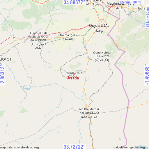
Jerada GPS coordinates[2]
34° 18' 36" North, 2° 9' 36" West
| Map corner | latitude | longitude |
|---|---|---|
| Upper-left | 34.88877°, | -2.86313° |
| Center: | 34.31°, | -2.16° |
| Lower-right: | 33.72722°, | -1.45688° |
| Map W x H: | 129.2×129.2 km | = 80.3×80.3mi |
| max Lat: | 35.84906° ⇑28.7% North |
| Jerada: | 34.31° |
| min Lat: | ⇓71.3% South 22.6558° |
| min Long | Jerada | max Long |
| -15.60719° | -2.16° | -1.22855° |
| W 97.3%⇐ | ⇒2.7% E |
Elevation
Elevation of Jerada is 1045 m = 3428 ft, and this is 428.2 m = 1405 ft above average elevation for this country.
| Max E: |
2637 m = 8652 ft | 20.5% |
| Jerada | 1045 m 3428 ft | |
| Avg. | 616.8 m = 2024 ft | |
Min E: |
1 m = 3 ft | 79.5% |
See also: Jerada elevation on elevation.city.
Geographical zone
Jerada is located in North temperate zone (between Tropic of Cancer and the Arctic Circle). Distance of this Northern Tropic circle is 1209 km =751.2 mi to South.| Distance of | km | miles | from Jerada |
|---|---|---|---|
| North Pole | 6192.1 | 3847.6 | to North |
| Arctic Circle | 3586.3 | 2228.4 | to North |
| Tropic Cancer | 1209 | 751.2 | to South |
| Equator | 3814.9 | 2370.5 | to South |


Nearby cities:
15 places around Jerada: (largest is in red/bold)
• Ahfir
71.8 km =44.6 mi,  4°
4°
• Aïn Beni Mathar
35.4 km =22 mi,  160°
160°
• Berkane
69.4 km =43.1 mi,  347°
347°
• Debdou
89 km =55.3 mi,  245°
245°
• El Aïoun
43.9 km =27.3 mi,  313°
313°
• Guenfouda
22 km =13.7 mi,  28°
28°
• Hassi Berkane
87.5 km =54.4 mi, 312°
• Madagh
79.5 km =49.4 mi, 348°
• Mosquée
59.8 km =37.2 mi,  337°
337°
• Oujda-Angad
47.3 km =29.4 mi, 29°
• Rislane
58.1 km =36.1 mi,  331°
331°
• Saidia
86.1 km =53.5 mi,  355°
355°
• Taourirt
68.5 km =42.6 mi,  279°
279°
• Tiouli
30.3 km =18.8 mi,  77°
77°
• Zaïo
87.7 km =54.5 mi,  323°
323°
Sources, notices
• [Note1] Compared only with cities in Morocco existing in our database
• [Src1] Map data: © OpenStreetMap contributors (CC-BY-SA)
• [Src2] Other city data from geonames.org with taken over terms of usage.
• [Src3] Geographical zone / Annual Mean Temperature by Robert A. Rohde @ Wikipedia
