Larache geodata
Larache (Tanger-Tetouan-Al Hoceima) is a seat of a third-order administrative division; located in Morocco in Africa/Casablanca (GMT+1) time zone. With population of 109,294 people, there are 22 cities with bigger population in this country. Compared to other cities in Morocco, 93.8% of cities are located further ↓South; 53.5% of cities are located further →East and 86.8% of cities have higher elevation than Larache. Note1


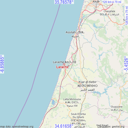
Larache GPS coordinates[2]
35° 11' 35.556" North, 6° 9' 20.592" West
| Map corner | latitude | longitude |
|---|---|---|
| Upper-left | 35.76578°, | -6.85885° |
| Center: | 35.19321°, | -6.15572° |
| Lower-right: | 34.61658°, | -5.4526° |
| Map W x H: | 127.8×127.8 km | = 79.4×79.4mi |
| max Lat: | 35.84906° ⇑6.2% North |
| Larache: | 35.19321° |
| min Lat: | ⇓93.8% South 22.6558° |
| min Long | Larache | max Long |
| -15.60719° | -6.15572° | -1.22855° |
| W 46.5%⇐ | ⇒53.5% E |
Elevation
Elevation of Larache is 38 m = 125 ft, and this is 578.8 m = 1899 ft below average elevation for this country.
| Max E: |
2637 m = 8652 ft | 86.8% |
| Avg. | 616.8 m = 2024 ft | |
| Larache | 38 m = 125 ft | |
Min E: |
1 m = 3 ft | 13.2% |
See also: Larache elevation on elevation.city.
Geographical zone
Larache is located in North temperate zone (between Tropic of Cancer and the Arctic Circle). Distance of this Northern Tropic circle is 1307.2 km =812.3 mi to South.| Distance of | km | miles | from Larache |
|---|---|---|---|
| North Pole | 6093.9 | 3786.6 | to North |
| Arctic Circle | 3488.1 | 2167.4 | to North |
| Tropic Cancer | 1307.2 | 812.3 | to South |
| Equator | 3913.1 | 2431.5 | to South |


Nearby cities:
15 places around Larache: (largest is in red/bold)
• Arbaoua
37.4 km =23.2 mi,  149°
149°
• Asilah
32.2 km =20 mi,  20°
20°
• Boukhalef
64.3 km =40 mi, 21°
• Brikcha
58.7 km =36.5 mi,  115°
115°
• Dar Chaoui
55.2 km =34.3 mi,  46°
46°
• Derdara
79.2 km =49.2 mi,  96°
96°
• Had Kourt
74.5 km =46.3 mi, 149°
• Ksar El Kebir
31.4 km =19.5 mi,  133°
133°
• Lalla Mimouna
39.4 km =24.5 mi,  168°
168°
• Mechraa Bel Ksiri
71.3 km =44.3 mi, 165°
• Ouezzane
68.7 km =42.7 mi, 130°
• Saddina
79.1 km =49.2 mi, 53°
• Souq Larb’a al Gharb
58 km =36 mi, 166°
• Tangier
71.5 km =44.4 mi,  26°
26°
• Zinat
73.4 km =45.6 mi,  68°
68°
Sources, notices
• [Note1] Compared only with cities in Morocco existing in our database
• [Src1] Map data: © OpenStreetMap contributors (CC-BY-SA)
• [Src2] Other city data from geonames.org with taken over terms of usage.
• [Src3] Geographical zone / Annual Mean Temperature by Robert A. Rohde @ Wikipedia
