Ouezzane geodata
Ouezzane (Tanger-Tetouan-Al Hoceima) is a seat of a second-order administrative division; located in Morocco in Africa/Casablanca (GMT+1) time zone. With population of 58,684 people, there are 43 cities with bigger population in this country. Compared to other cities in Morocco, 81.4% of cities are located further ↓South; 57.4% of cities are located further ←West and 63.2% of cities have higher elevation than Ouezzane. Note1


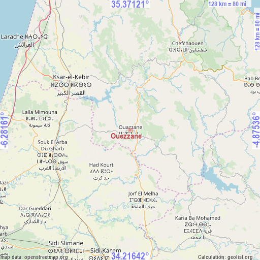
Ouezzane GPS coordinates[2]
34° 47' 45.024" North, 5° 34' 42.564" West
| Map corner | latitude | longitude |
|---|---|---|
| Upper-left | 35.37121°, | -6.28161° |
| Center: | 34.79584°, | -5.57849° |
| Lower-right: | 34.21642°, | -4.87536° |
| Map W x H: | 128.4×128.4 km | = 79.8×79.8mi |
| max Lat: | 35.84906° ⇑18.6% North |
| Ouezzane: | 34.79584° |
| min Lat: | ⇓81.4% South 22.6558° |
| min Long | Ouezzane | max Long |
| -15.60719° | -5.57849° | -1.22855° |
| W 57.4%⇐ | ⇒42.6% E |
Elevation
Elevation of Ouezzane is 306 m = 1004 ft, and this is 310.8 m = 1020 ft below average elevation for this country.
| Max E: |
2637 m = 8652 ft | 63.2% |
| Avg. | 616.8 m = 2024 ft | |
| Ouezzane | 306 m = 1004 ft | |
Min E: |
1 m = 3 ft | 36.8% |
See also: Ouezzane elevation on elevation.city.
Geographical zone
Ouezzane is located in North temperate zone (between Tropic of Cancer and the Arctic Circle). Distance of this Northern Tropic circle is 1263 km =784.8 mi to South.| Distance of | km | miles | from Ouezzane |
|---|---|---|---|
| North Pole | 6138.1 | 3814 | to North |
| Arctic Circle | 3532.2 | 2194.8 | to North |
| Tropic Cancer | 1263 | 784.8 | to South |
| Equator | 3868.9 | 2404 | to South |


Nearby cities:
15 places around Ouezzane: (largest is in red/bold)
• Arbaoua
35.8 km =22.2 mi,  289°
289°
• Brikcha
19.1 km =11.9 mi,  1°
1°
• Derdara
43.7 km =27.2 mi,  36°
36°
• Fifi
34.6 km =21.5 mi,  60°
60°
• Ghouazi
43.5 km =27 mi,  144°
144°
• Had Kourt
24.9 km =15.5 mi,  216°
216°
• Ksar El Kebir
37.4 km =23.2 mi,  307°
307°
• Mahroun
41.8 km =26 mi,  48°
48°
• Mechraa Bel Ksiri
42.4 km =26.3 mi,  234°
234°
• Sidi Bousber
32.6 km =20.3 mi, 142°
• Sidi Redouane
17.2 km =10.7 mi,  134°
134°
• Souq Larb’a al Gharb
40.6 km =25.2 mi,  252°
252°
• Tabouda
40.9 km =25.4 mi,  102°
102°
• Teroual
31 km =19.3 mi,  115°
115°
• Zoumi
21.4 km =13.3 mi,  87°
87°
Sources, notices
• [Note1] Compared only with cities in Morocco existing in our database
• [Src1] Map data: © OpenStreetMap contributors (CC-BY-SA)
• [Src2] Other city data from geonames.org with taken over terms of usage.
• [Src3] Geographical zone / Annual Mean Temperature by Robert A. Rohde @ Wikipedia
