Ksar El Kebir geodata
Ksar El Kebir (Tanger-Tetouan-Al Hoceima) is a populated place; located in Morocco in Africa/Casablanca (GMT+1) time zone. With population of 108,753 people, there are 23 cities with bigger population in this country. Compared to other cities in Morocco, 87.2% of cities are located further ↓South; 51.9% of cities are located further ←West and 94.2% of cities have higher elevation than Ksar El Kebir. Note1


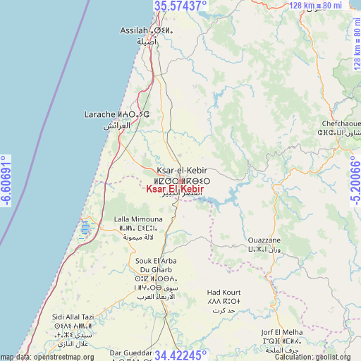
Ksar El Kebir GPS coordinates[2]
35° 0' 1.584" North, 5° 54' 13.608" West
| Map corner | latitude | longitude |
|---|---|---|
| Upper-left | 35.57437°, | -6.60691° |
| Center: | 35.00044°, | -5.90378° |
| Lower-right: | 34.42245°, | -5.20066° |
| Map W x H: | 128.1×128.1 km | = 79.6×79.6mi |
| max Lat: | 35.84906° ⇑12.8% North |
| Ksar El Kebir: | 35.00044° |
| min Lat: | ⇓87.2% South 22.6558° |
| min Long | Ksar El Kebir | max Long |
| -15.60719° | -5.90378° | -1.22855° |
| W 51.9%⇐ | ⇒48.1% E |
Elevation
Elevation of Ksar El Kebir is 18 m = 59 ft, and this is 598.8 m = 1965 ft below average elevation for this country.
| Max E: |
2637 m = 8652 ft | 94.2% |
| Avg. | 616.8 m = 2024 ft | |
| Ksar El Kebir | 18 m = 59 ft | |
Min E: |
1 m = 3 ft | 5.8% |
See also: Ksar El Kebir elevation on elevation.city.
Geographical zone
Ksar El Kebir is located in North temperate zone (between Tropic of Cancer and the Arctic Circle). Distance of this Northern Tropic circle is 1285.8 km =799 mi to South.| Distance of | km | miles | from Ksar El Kebir |
|---|---|---|---|
| North Pole | 6115.4 | 3799.9 | to North |
| Arctic Circle | 3509.5 | 2180.7 | to North |
| Tropic Cancer | 1285.8 | 799 | to South |
| Equator | 3891.7 | 2418.2 | to South |


Nearby cities:
15 places around Ksar El Kebir: (largest is in red/bold)
• Arbaoua
11.6 km =7.2 mi,  200°
200°
• Asilah
53 km =32.9 mi,  347°
347°
• Brikcha
30.4 km =18.9 mi,  96°
96°
• Chefchaouene
61.2 km =38 mi,  72°
72°
• Derdara
57.2 km =35.5 mi,  77°
77°
• Fifi
60 km =37.3 mi, 95°
• Had Kourt
45.3 km =28.1 mi,  160°
160°
• Lalla Mimouna
22.7 km =14.1 mi,  220°
220°
• Larache
31.4 km =19.5 mi,  313°
313°
• Mahroun
61.2 km =38 mi,  85°
85°
• Mechraa Bel Ksiri
47.7 km =29.6 mi,  185°
185°
• Ouezzane
37.4 km =23.2 mi,  127°
127°
• Sidi Redouane
54.5 km =33.9 mi, 129°
• Souq Larb’a al Gharb
36 km =22.4 mi, 194°
• Zoumi
55.5 km =34.5 mi,  113°
113°
Sources, notices
• [Note1] Compared only with cities in Morocco existing in our database
• [Src1] Map data: © OpenStreetMap contributors (CC-BY-SA)
• [Src2] Other city data from geonames.org with taken over terms of usage.
• [Src3] Geographical zone / Annual Mean Temperature by Robert A. Rohde @ Wikipedia
