Asilah geodata
Asilah (Tanger-Tetouan-Al Hoceima) is a populated place; located in Morocco in Africa/Casablanca (GMT+1) time zone. With population of 28,861 people, there are 69 cities with bigger population in this country. Compared to other cities in Morocco, 96.1% of cities are located further ↓South; 51.6% of cities are located further →East and 95% of cities have higher elevation than Asilah. Note1


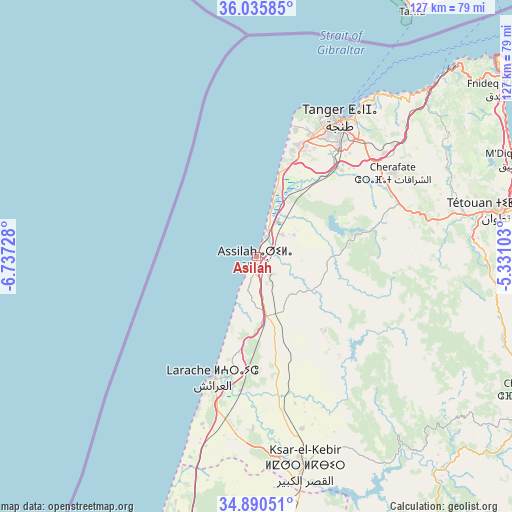
Asilah GPS coordinates[2]
35° 27' 54.792" North, 6° 2' 2.94" West
| Map corner | latitude | longitude |
|---|---|---|
| Upper-left | 36.03585°, | -6.73728° |
| Center: | 35.46522°, | -6.03415° |
| Lower-right: | 34.89051°, | -5.33103° |
| Map W x H: | 127.3×127.3 km | = 79.1×79.1mi |
| max Lat: | 35.84906° ⇑3.9% North |
| Asilah: | 35.46522° |
| min Lat: | ⇓96.1% South 22.6558° |
| min Long | Asilah | max Long |
| -15.60719° | -6.03415° | -1.22855° |
| W 48.4%⇐ | ⇒51.6% E |
Elevation
Elevation of Asilah is 17 m = 56 ft, and this is 599.8 m = 1968 ft below average elevation for this country.
| Max E: |
2637 m = 8652 ft | 95% |
| Avg. | 616.8 m = 2024 ft | |
| Asilah | 17 m = 56 ft | |
Min E: |
1 m = 3 ft | 5% |
See also: Morocco elevation on elevation.city.
Geographical zone
Asilah is located in North temperate zone (between Tropic of Cancer and the Arctic Circle). Distance of this Northern Tropic circle is 1337.4 km =831 mi to South.| Distance of | km | miles | from Asilah |
|---|---|---|---|
| North Pole | 6063.7 | 3767.8 | to North |
| Arctic Circle | 3457.8 | 2148.6 | to North |
| Tropic Cancer | 1337.4 | 831 | to South |
| Equator | 3943.4 | 2450.3 | to South |


Nearby cities:
15 places around Asilah: (largest is in red/bold)
• Arbaoua
63.1 km =39.2 mi,  172°
172°
• Azla
72.1 km =44.8 mi,  82°
82°
• Boukhalef
32.1 km =19.9 mi,  22°
22°
• Brikcha
69.4 km =43.1 mi,  142°
142°
• Cap Negro II
71.1 km =44.2 mi,  72°
72°
• Dar Chaoui
29.8 km =18.5 mi, 74°
• Ksar El Kebir
53 km =32.9 mi, 167°
• Lalla Mimouna
68.9 km =42.8 mi,  182°
182°
• Larache
32.2 km =20 mi,  200°
200°
• Martil
70.7 km =43.9 mi, 76°
• Mdiq
68.2 km =42.4 mi, 69°
• Saddina
55.2 km =34.3 mi, 72°
• Tangier
39.7 km =24.7 mi,  32°
32°
• Tétouan
61.6 km =38.3 mi, 78°
• Zinat
57.6 km =35.8 mi,  93°
93°
Sources, notices
• [Note1] Compared only with cities in Morocco existing in our database
• [Src1] Map data: © OpenStreetMap contributors (CC-BY-SA)
• [Src2] Other city data from geonames.org with taken over terms of usage.
• [Src3] Geographical zone / Annual Mean Temperature by Robert A. Rohde @ Wikipedia
