Arfoud geodata
Arfoud (Drâa-Tafilalet) is a populated place; located in Morocco in Africa/Casablanca (GMT+1) time zone. With population of 23,637 people, there are 75 cities with bigger population in this country. Compared to other cities in Morocco, 75.6% of cities are located further ↑North; 83.7% of cities are located further ←West and 64.7% of cities have lower elevation than Arfoud. Note1


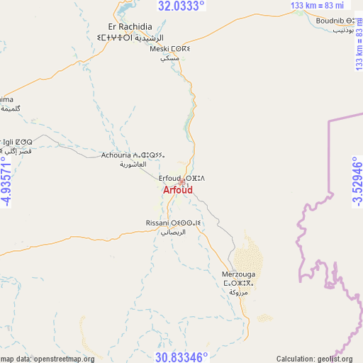
Arfoud GPS coordinates[2]
31° 26' 7.08" North, 4° 13' 57.288" West
| Map corner | latitude | longitude |
|---|---|---|
| Upper-left | 32.0333°, | -4.93571° |
| Center: | 31.4353°, | -4.23258° |
| Lower-right: | 30.83346°, | -3.52946° |
| Map W x H: | 133.4×133.4 km | = 82.9×82.9mi |
| max Lat: | 35.84906° ⇑75.6% North |
| Arfoud: | 31.4353° |
| min Lat: | ⇓24.4% South 22.6558° |
| min Long | Arfoud | max Long |
| -15.60719° | -4.23258° | -1.22855° |
| W 83.7%⇐ | ⇒16.3% E |
Elevation
Elevation of Arfoud is 809 m = 2654 ft, and this is 192.2 m = 631 ft above average elevation for this country.
| Max E: |
2637 m = 8652 ft | 35.3% |
| Arfoud | 809 m 2654 ft | |
| Avg. | 616.8 m = 2024 ft | |
Min E: |
1 m = 3 ft | 64.7% |
See also: Morocco elevation on elevation.city.
Geographical zone
Arfoud is located in North temperate zone (between Tropic of Cancer and the Arctic Circle). Distance of this Northern Tropic circle is 889.4 km =552.6 mi to South.| Distance of | km | miles | from Arfoud |
|---|---|---|---|
| North Pole | 6511.8 | 4046.2 | to North |
| Arctic Circle | 3905.9 | 2427 | to North |
| Tropic Cancer | 889.4 | 552.6 | to South |
| Equator | 3495.3 | 2171.9 | to South |


Nearby cities:
15 places around Arfoud: (largest is in red/bold)
• Alnif
96.1 km =59.7 mi,  248°
248°
• Amersid
147.9 km =91.9 mi,  351°
351°
• Amouguer
114.5 km =71.1 mi,  324°
324°
• Aoufous
27.8 km =17.3 mi,  12°
12°
• Assoul
108.8 km =67.6 mi,  301°
301°
• Errachidia
58.1 km =36.1 mi,  341°
341°
• Fezna
23.6 km =14.7 mi, 296°
• Goulmima
74 km =46 mi,  292°
292°
• Imider
148.3 km =92.1 mi,  267°
267°
• Jebel Tiskaouine
95.5 km =59.3 mi,  241°
241°
• Jorf
17.7 km =11 mi, 291°
• Midelt
147.1 km =91.4 mi, 340°
• Reçani
17.2 km =10.7 mi,  190°
190°
• Tilmi
151.5 km =94.1 mi, 286°
• Tinghir
123.6 km =76.8 mi, 274°
Sources, notices
• [Note1] Compared only with cities in Morocco existing in our database
• [Src1] Map data: © OpenStreetMap contributors (CC-BY-SA)
• [Src2] Other city data from geonames.org with taken over terms of usage.
• [Src3] Geographical zone / Annual Mean Temperature by Robert A. Rohde @ Wikipedia
