Goulmima geodata
Goulmima (Drâa-Tafilalet) is a seat of a third-order administrative division; located in Morocco in Africa/Casablanca (GMT+1) time zone. In our database, there are 108 cities with bigger population. Compared to other cities in Morocco, 69.4% of cities are located further ↑North; 74% of cities are located further ←West and 77.5% of cities have lower elevation than Goulmima. Note1


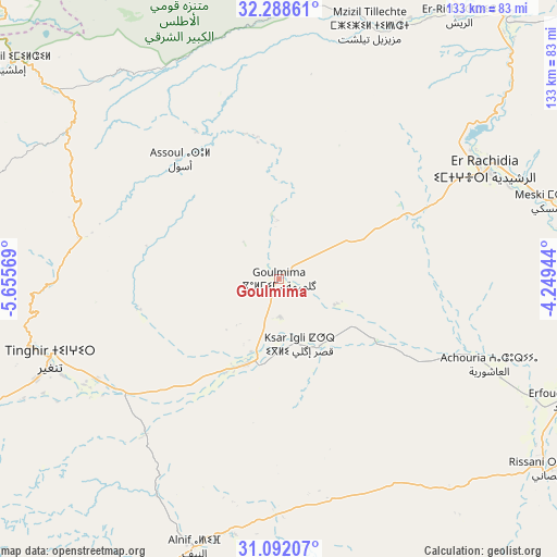
Goulmima GPS coordinates[2]
31° 41' 32.172" North, 4° 57' 9.216" West
| Map corner | latitude | longitude |
|---|---|---|
| Upper-left | 32.28861°, | -5.65569° |
| Center: | 31.69227°, | -4.95256° |
| Lower-right: | 31.09207°, | -4.24944° |
| Map W x H: | 133×133 km | = 82.6×82.6mi |
| max Lat: | 35.84906° ⇑69.4% North |
| Goulmima: | 31.69227° |
| min Lat: | ⇓30.6% South 22.6558° |
| min Long | Goulmima | max Long |
| -15.60719° | -4.95256° | -1.22855° |
| W 74%⇐ | ⇒26% E |
Elevation
Elevation of Goulmima is 1028 m = 3373 ft, and this is 411.2 m = 1349 ft above average elevation for this country.
| Max E: |
2637 m = 8652 ft | 22.5% |
| Goulmima | 1028 m 3373 ft | |
| Avg. | 616.8 m = 2024 ft | |
Min E: |
1 m = 3 ft | 77.5% |
See also: Morocco elevation on elevation.city.
Geographical zone
Goulmima is located in North temperate zone (between Tropic of Cancer and the Arctic Circle). Distance of this Northern Tropic circle is 917.9 km =570.4 mi to South.| Distance of | km | miles | from Goulmima |
|---|---|---|---|
| North Pole | 6483.2 | 4028.5 | to North |
| Arctic Circle | 3877.3 | 2409.2 | to North |
| Tropic Cancer | 917.9 | 570.4 | to South |
| Equator | 3523.9 | 2189.6 | to South |


Nearby cities:
15 places around Goulmima: (largest is in red/bold)
• Alnif
67.6 km =42 mi,  197°
197°
• Amouguer
64.8 km =40.3 mi,  1°
1°
• Anergui
102.2 km =63.5 mi,  294°
294°
• Aoufous
74.1 km =46 mi,  91°
91°
• Arfoud
74 km =46 mi,  112°
112°
• Assoul
37.7 km =23.4 mi,  320°
320°
• Errachidia
56.4 km =35 mi,  61°
61°
• Fezna
50.4 km =31.3 mi, 111°
• Imider
87.3 km =54.2 mi,  246°
246°
• Imilchil
81.5 km =50.6 mi,  308°
308°
• Jebel Tiskaouine
75.6 km =47 mi,  191°
191°
• Jorf
56.2 km =34.9 mi, 113°
• Reçani
79.4 km =49.3 mi,  124°
124°
• Tilmi
78.4 km =48.7 mi,  280°
280°
• Tinghir
58.4 km =36.3 mi, 250°
Sources, notices
• [Note1] Compared only with cities in Morocco existing in our database
• [Src1] Map data: © OpenStreetMap contributors (CC-BY-SA)
• [Src2] Other city data from geonames.org with taken over terms of usage.
• [Src3] Geographical zone / Annual Mean Temperature by Robert A. Rohde @ Wikipedia
