Reçani geodata
Reçani (Drâa-Tafilalet) is a populated place; located in Morocco in Africa/Casablanca (GMT+1) time zone. With population of 20,469 people, there are 77 cities with bigger population in this country. Compared to other cities in Morocco, 77.1% of cities are located further ↑North; 83.3% of cities are located further ←West and 62.8% of cities have lower elevation than Reçani. Note1


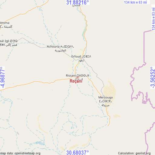
Reçani GPS coordinates[2]
31° 16' 59.448" North, 4° 15' 56.34" West
| Map corner | latitude | longitude |
|---|---|---|
| Upper-left | 31.88216°, | -4.96877° |
| Center: | 31.28318°, | -4.26565° |
| Lower-right: | 30.68037°, | -3.56252° |
| Map W x H: | 133.6×133.6 km | = 83×83mi |
| max Lat: | 35.84906° ⇑77.1% North |
| Reçani: | 31.28318° |
| min Lat: | ⇓22.9% South 22.6558° |
| min Long | Reçani | max Long |
| -15.60719° | -4.26565° | -1.22855° |
| W 83.3%⇐ | ⇒16.7% E |
Elevation
Elevation of Reçani is 761 m = 2497 ft, and this is 144.2 m = 473 ft above average elevation for this country.
| Max E: |
2637 m = 8652 ft | 37.2% |
| Reçani | 761 m 2497 ft | |
| Avg. | 616.8 m = 2024 ft | |
Min E: |
1 m = 3 ft | 62.8% |
See also: Morocco elevation on elevation.city.
Geographical zone
Reçani is located in North temperate zone (between Tropic of Cancer and the Arctic Circle). Distance of this Northern Tropic circle is 872.4 km =542.1 mi to South.| Distance of | km | miles | from Reçani |
|---|---|---|---|
| North Pole | 6528.7 | 4056.7 | to North |
| Arctic Circle | 3922.8 | 2437.5 | to North |
| Tropic Cancer | 872.4 | 542.1 | to South |
| Equator | 3478.4 | 2161.4 | to South |


Nearby cities:
15 places around Reçani: (largest is in red/bold)
• Alnif
88.2 km =54.8 mi,  257°
257°
• Amouguer
127.1 km =79 mi,  330°
330°
• Aoufous
45 km =28 mi,  11°
11°
• Arfoud
17.2 km =10.7 mi, 10°
• Assoul
116.2 km =72.2 mi,  309°
309°
• Errachidia
73.7 km =45.8 mi,  348°
348°
• Fezna
32.8 km =20.4 mi, 326°
• Goulmima
79.4 km =49.3 mi,  304°
304°
• Imider
145.5 km =90.4 mi,  273°
273°
• Imilchil
160.9 km =100 mi, 306°
• Jebel Tiskaouine
85.8 km =53.3 mi,  250°
250°
• Jorf
27 km =16.8 mi, 330°
• Midelt
162.3 km =100.8 mi,  343°
343°
• Tilmi
154.3 km =95.9 mi,  292°
292°
• Tinghir
123 km =76.4 mi,  282°
282°
Sources, notices
• [Note1] Compared only with cities in Morocco existing in our database
• [Src1] Map data: © OpenStreetMap contributors (CC-BY-SA)
• [Src2] Other city data from geonames.org with taken over terms of usage.
• [Src3] Geographical zone / Annual Mean Temperature by Robert A. Rohde @ Wikipedia
