Errachidia geodata
Errachidia (Drâa-Tafilalet) is a seat of a third-order administrative division; located in Morocco in Africa/Casablanca (GMT+1) time zone. With population of 92,374 people, there are 27 cities with bigger population in this country. Compared to other cities in Morocco, 66.7% of cities are located further ↑North; 81.4% of cities are located further ←West and 78.7% of cities have lower elevation than Errachidia. Note1


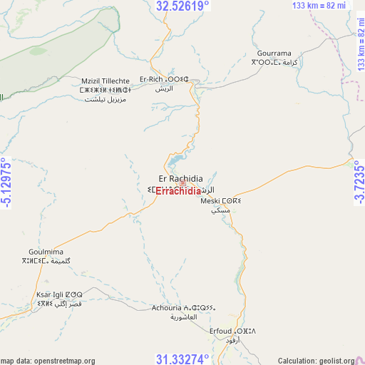
Errachidia GPS coordinates[2]
31° 55' 53.04" North, 4° 25' 35.868" West
| Map corner | latitude | longitude |
|---|---|---|
| Upper-left | 32.52619°, | -5.12975° |
| Center: | 31.9314°, | -4.42663° |
| Lower-right: | 31.33274°, | -3.7235° |
| Map W x H: | 132.7×132.7 km | = 82.5×82.5mi |
| max Lat: | 35.84906° ⇑66.7% North |
| Errachidia: | 31.9314° |
| min Lat: | ⇓33.3% South 22.6558° |
| min Long | Errachidia | max Long |
| -15.60719° | -4.42663° | -1.22855° |
| W 81.4%⇐ | ⇒18.6% E |
Elevation
Elevation of Errachidia is 1039 m = 3409 ft, and this is 422.2 m = 1385 ft above average elevation for this country.
| Max E: |
2637 m = 8652 ft | 21.3% |
| Errachidia | 1039 m 3409 ft | |
| Avg. | 616.8 m = 2024 ft | |
Min E: |
1 m = 3 ft | 78.7% |
See also: Errachidia elevation on elevation.city.
Geographical zone
Errachidia is located in North temperate zone (between Tropic of Cancer and the Arctic Circle). Distance of this Northern Tropic circle is 944.5 km =586.9 mi to South.| Distance of | km | miles | from Errachidia |
|---|---|---|---|
| North Pole | 6456.6 | 4011.9 | to North |
| Arctic Circle | 3850.7 | 2392.7 | to North |
| Tropic Cancer | 944.5 | 586.9 | to South |
| Equator | 3550.4 | 2206.1 | to South |


Nearby cities:
15 places around Errachidia: (largest is in red/bold)
• Alnif
115.1 km =71.5 mi,  217°
217°
• Amersid
91.1 km =56.6 mi,  357°
357°
• Amouguer
61.3 km =38.1 mi,  308°
308°
• Aoufous
37 km =23 mi,  139°
139°
• Arfoud
58.1 km =36.1 mi,  161°
161°
• Assoul
73.8 km =45.9 mi,  271°
271°
• Boumia
108.6 km =67.5 mi,  324°
324°
• Fezna
44.8 km =27.8 mi,  183°
183°
• Goulmima
56.4 km =35 mi,  241°
241°
• Imilchil
115.6 km =71.8 mi,  282°
282°
• Jebel Tiskaouine
119.9 km =74.5 mi,  213°
213°
• Jorf
48.6 km =30.2 mi, 177°
• Midelt
89 km =55.3 mi,  340°
340°
• Reçani
73.7 km =45.8 mi,  168°
168°
• Tinghir
114.4 km =71.1 mi,  246°
246°
In other languages:
- In Spanish: Er-Rachidía
- In Italian: Al-Rashidiyya
- In Russian: Эр-Рашидия
- In Chinese: 拉希迪耶
Sources, notices
• [Note1] Compared only with cities in Morocco existing in our database
• [Src1] Map data: © OpenStreetMap contributors (CC-BY-SA)
• [Src2] Other city data from geonames.org with taken over terms of usage.
• [Src3] Geographical zone / Annual Mean Temperature by Robert A. Rohde @ Wikipedia
