Fezna geodata
Fezna (Drâa-Tafilalet) is a seat of a third-order administrative division; located in Morocco in Africa/Casablanca (GMT+1) time zone. In our database, there are 108 cities with bigger population. Compared to other cities in Morocco, 72.9% of cities are located further ↑North; 81% of cities are located further ←West and 66.3% of cities have lower elevation than Fezna. Note1


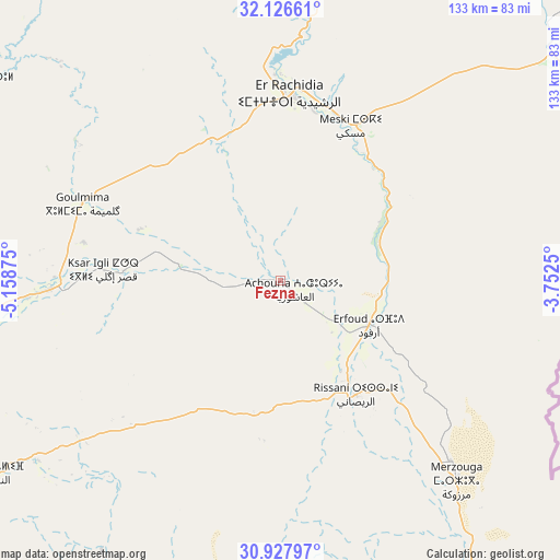
Fezna GPS coordinates[2]
31° 31' 45.156" North, 4° 27' 20.232" West
| Map corner | latitude | longitude |
|---|---|---|
| Upper-left | 32.12661°, | -5.15875° |
| Center: | 31.52921°, | -4.45562° |
| Lower-right: | 30.92797°, | -3.7525° |
| Map W x H: | 133.3×133.3 km | = 82.8×82.8mi |
| max Lat: | 35.84906° ⇑72.9% North |
| Fezna: | 31.52921° |
| min Lat: | ⇓27.1% South 22.6558° |
| min Long | Fezna | max Long |
| -15.60719° | -4.45562° | -1.22855° |
| W 81%⇐ | ⇒19% E |
Elevation
Elevation of Fezna is 837 m = 2746 ft, and this is 220.2 m = 722 ft above average elevation for this country.
| Max E: |
2637 m = 8652 ft | 33.7% |
| Fezna | 837 m 2746 ft | |
| Avg. | 616.8 m = 2024 ft | |
Min E: |
1 m = 3 ft | 66.3% |
See also: Morocco elevation on elevation.city.
Geographical zone
Fezna is located in North temperate zone (between Tropic of Cancer and the Arctic Circle). Distance of this Northern Tropic circle is 899.8 km =559.1 mi to South.| Distance of | km | miles | from Fezna |
|---|---|---|---|
| North Pole | 6501.3 | 4039.7 | to North |
| Arctic Circle | 3895.5 | 2420.6 | to North |
| Tropic Cancer | 899.8 | 559.1 | to South |
| Equator | 3505.7 | 2178.3 | to South |


Nearby cities:
15 places around Fezna: (largest is in red/bold)
• Alnif
82.2 km =51.1 mi,  235°
235°
• Amouguer
94.5 km =58.7 mi,  331°
331°
• Aoufous
31.8 km =19.8 mi,  58°
58°
• Arfoud
23.6 km =14.7 mi,  116°
116°
• Assoul
85.3 km =53 mi,  303°
303°
• Errachidia
44.8 km =27.8 mi,  3°
3°
• Goulmima
50.4 km =31.3 mi,  291°
291°
• Imider
128.1 km =79.6 mi,  262°
262°
• Imilchil
130.4 km =81 mi, 302°
• Jebel Tiskaouine
84 km =52.2 mi,  228°
228°
• Jorf
6.1 km =3.8 mi,  129°
129°
• Midelt
131.4 km =81.6 mi,  348°
348°
• Reçani
32.8 km =20.4 mi,  146°
146°
• Tilmi
128.3 km =79.7 mi,  284°
284°
• Tinghir
102.1 km =63.4 mi,  269°
269°
Sources, notices
• [Note1] Compared only with cities in Morocco existing in our database
• [Src1] Map data: © OpenStreetMap contributors (CC-BY-SA)
• [Src2] Other city data from geonames.org with taken over terms of usage.
• [Src3] Geographical zone / Annual Mean Temperature by Robert A. Rohde @ Wikipedia
