Tinghir geodata
Tinghir (Drâa-Tafilalet) is a seat of a second-order administrative division; located in Morocco in Africa/Casablanca (GMT+1) time zone. With population of 36,795 people, there are 61 cities with bigger population in this country. Compared to other cities in Morocco, 73.6% of cities are located further ↑North; 58.9% of cities are located further ←West and 88% of cities have lower elevation than Tinghir. Note1


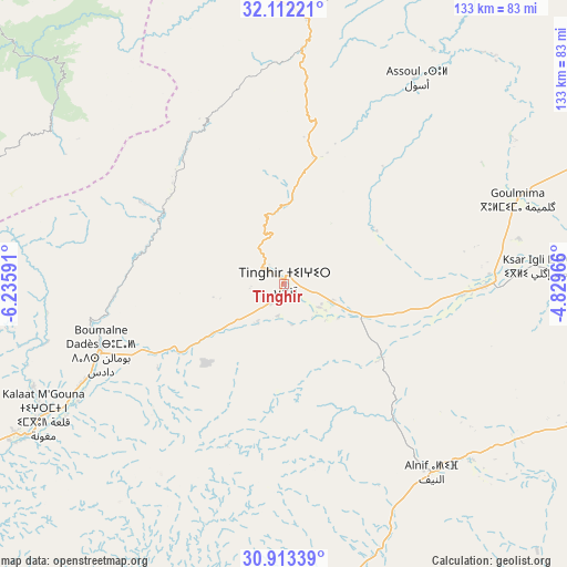
Tinghir GPS coordinates[2]
31° 30' 52.992" North, 5° 31' 58.008" West
| Map corner | latitude | longitude |
|---|---|---|
| Upper-left | 32.11221°, | -6.23591° |
| Center: | 31.51472°, | -5.53278° |
| Lower-right: | 30.91339°, | -4.82966° |
| Map W x H: | 133.3×133.3 km | = 82.8×82.8mi |
| max Lat: | 35.84906° ⇑73.6% North |
| Tinghir: | 31.51472° |
| min Lat: | ⇓26.4% South 22.6558° |
| min Long | Tinghir | max Long |
| -15.60719° | -5.53278° | -1.22855° |
| W 58.9%⇐ | ⇒41.1% E |
Elevation
Elevation of Tinghir is 1281 m = 4203 ft, and this is 664.2 m = 2179 ft above average elevation for this country.
| Max E: |
2637 m = 8652 ft | 12% |
| Tinghir | 1281 m 4203 ft | |
| Avg. | 616.8 m = 2024 ft | |
Min E: |
1 m = 3 ft | 88% |
See also: Morocco elevation on elevation.city.
Geographical zone
Tinghir is located in North temperate zone (between Tropic of Cancer and the Arctic Circle). Distance of this Northern Tropic circle is 898.2 km =558.1 mi to South.| Distance of | km | miles | from Tinghir |
|---|---|---|---|
| North Pole | 6503 | 4040.8 | to North |
| Arctic Circle | 3897.1 | 2421.5 | to North |
| Tropic Cancer | 898.2 | 558.1 | to South |
| Equator | 3504.1 | 2177.3 | to South |


Nearby cities:
15 places around Tinghir: (largest is in red/bold)
• Alnif
56.2 km =34.9 mi,  142°
142°
• Amouguer
101.6 km =63.1 mi,  33°
33°
• Anergui
72.7 km =45.2 mi,  328°
328°
• Assoul
57.6 km =35.8 mi, 32°
• Fezna
102.1 km =63.4 mi,  89°
89°
• Goulmima
58.4 km =36.3 mi,  70°
70°
• Ifrane
80.1 km =49.8 mi,  285°
285°
• Imider
29.3 km =18.2 mi,  237°
237°
• Imilchil
71.5 km =44.4 mi,  353°
353°
• Isseksi
106.1 km =65.9 mi,  318°
318°
• Jebel Tiskaouine
67.1 km =41.7 mi, 143°
• Jorf
106.8 km =66.4 mi, 91°
• Kelaat Mgouna
64.3 km =40 mi, 242°
• Tabant
84.5 km =52.5 mi,  280°
280°
• Tilmi
40.4 km =25.1 mi, 326°
Sources, notices
• [Note1] Compared only with cities in Morocco existing in our database
• [Src1] Map data: © OpenStreetMap contributors (CC-BY-SA)
• [Src2] Other city data from geonames.org with taken over terms of usage.
• [Src3] Geographical zone / Annual Mean Temperature by Robert A. Rohde @ Wikipedia
