Assoul geodata
Assoul (Drâa-Tafilalet) is a seat of a third-order administrative division; located in Morocco in Africa/Casablanca (GMT+1) time zone. In our database, there are 108 cities with bigger population. Compared to other cities in Morocco, 66.3% of cities are located further ↑North; 67.8% of cities are located further ←West and 95% of cities have lower elevation than Assoul. Note1


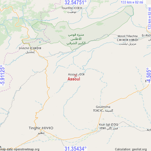
Assoul GPS coordinates[2]
31° 57' 10.296" North, 5° 12' 29.232" West
| Map corner | latitude | longitude |
|---|---|---|
| Upper-left | 32.54751°, | -5.91125° |
| Center: | 31.95286°, | -5.20812° |
| Lower-right: | 31.35434°, | -4.505° |
| Map W x H: | 132.7×132.7 km | = 82.5×82.5mi |
| max Lat: | 35.84906° ⇑66.3% North |
| Assoul: | 31.95286° |
| min Lat: | ⇓33.7% South 22.6558° |
| min Long | Assoul | max Long |
| -15.60719° | -5.20812° | -1.22855° |
| W 67.8%⇐ | ⇒32.2% E |
Elevation
Elevation of Assoul is 1641 m = 5384 ft, and this is 1024.2 m = 3360 ft above average elevation for this country.
| Max E: |
2637 m = 8652 ft | 5% |
| Assoul | 1641 m 5384 ft | |
| Avg. | 616.8 m = 2024 ft | |
Min E: |
1 m = 3 ft | 95% |
See also: Morocco elevation on elevation.city.
Geographical zone
Assoul is located in North temperate zone (between Tropic of Cancer and the Arctic Circle). Distance of this Northern Tropic circle is 946.9 km =588.4 mi to South.| Distance of | km | miles | from Assoul |
|---|---|---|---|
| North Pole | 6454.2 | 4010.5 | to North |
| Arctic Circle | 3848.3 | 2391.2 | to North |
| Tropic Cancer | 946.9 | 588.4 | to South |
| Equator | 3552.8 | 2207.6 | to South |


Nearby cities:
15 places around Assoul: (largest is in red/bold)
• Alnif
93.3 km =58 mi,  177°
177°
• Amouguer
44.1 km =27.4 mi,  35°
35°
• Anergui
70.2 km =43.6 mi,  280°
280°
• Boumia
86.3 km =53.6 mi,  6°
6°
• Errachidia
73.8 km =45.9 mi,  91°
91°
• Fezna
85.3 km =53 mi,  123°
123°
• Goulmima
37.7 km =23.4 mi,  140°
140°
• Imider
85 km =52.8 mi,  220°
220°
• Imilchil
45.1 km =28 mi,  299°
299°
• Jorf
91.4 km =56.8 mi, 123°
• Kerrouchen
94.4 km =58.7 mi,  353°
353°
• Midelt
92.3 km =57.4 mi,  28°
28°
• Sidi Yahya Ou Saad
88 km =54.7 mi,  336°
336°
• Tilmi
55 km =34.2 mi,  254°
254°
• Tinghir
57.6 km =35.8 mi,  212°
212°
Sources, notices
• [Note1] Compared only with cities in Morocco existing in our database
• [Src1] Map data: © OpenStreetMap contributors (CC-BY-SA)
• [Src2] Other city data from geonames.org with taken over terms of usage.
• [Src3] Geographical zone / Annual Mean Temperature by Robert A. Rohde @ Wikipedia
