Debdou geodata
Debdou (Oriental) is a seat of a third-order administrative division; located in Morocco in Africa/Casablanca (GMT+1) time zone. In our database, there are 108 cities with bigger population. Compared to other cities in Morocco, 64.3% of cities are located further ↓South; 91.5% of cities are located further ←West and 75.2% of cities have lower elevation than Debdou. Note1


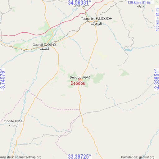
Debdou GPS coordinates[2]
33° 58' 56.208" North, 3° 2' 33.468" West
| Map corner | latitude | longitude |
|---|---|---|
| Upper-left | 34.56331°, | -3.74576° |
| Center: | 33.98228°, | -3.04263° |
| Lower-right: | 33.39725°, | -2.33951° |
| Map W x H: | 129.7×129.7 km | = 80.6×80.6mi |
| max Lat: | 35.84906° ⇑35.7% North |
| Debdou: | 33.98228° |
| min Lat: | ⇓64.3% South 22.6558° |
| min Long | Debdou | max Long |
| -15.60719° | -3.04263° | -1.22855° |
| W 91.5%⇐ | ⇒8.5% E |
Elevation
Elevation of Debdou is 994 m = 3261 ft, and this is 377.2 m = 1238 ft above average elevation for this country.
| Max E: |
2637 m = 8652 ft | 24.8% |
| Debdou | 994 m 3261 ft | |
| Avg. | 616.8 m = 2024 ft | |
Min E: |
1 m = 3 ft | 75.2% |
See also: Morocco elevation on elevation.city.
Geographical zone
Debdou is located in North temperate zone (between Tropic of Cancer and the Arctic Circle). Distance of this Northern Tropic circle is 1172.6 km =728.6 mi to South.| Distance of | km | miles | from Debdou |
|---|---|---|---|
| North Pole | 6228.6 | 3870.3 | to North |
| Arctic Circle | 3622.7 | 2251 | to North |
| Tropic Cancer | 1172.6 | 728.6 | to South |
| Equator | 3778.5 | 2347.9 | to South |


Nearby cities:
15 places around Debdou: (largest is in red/bold)
• Aknoul
106.4 km =66.1 mi,  314°
314°
• Aïn Beni Mathar
93.2 km =57.9 mi,  88°
88°
• El Aïoun
83 km =51.6 mi,  36°
36°
• Guenfouda
107.3 km =66.7 mi,  58°
58°
• Guercif
39.4 km =24.5 mi, 313°
• Hassi Berkane
96.6 km =60 mi,  9°
9°
• Jerada
89 km =55.3 mi,  65°
65°
• Mosquée
108.3 km =67.3 mi,  32°
32°
• Rislane
102.6 km =63.8 mi, 31°
• Taourirt
49.1 km =30.5 mi,  15°
15°
• Taza
92.6 km =57.5 mi,  285°
285°
• Tazarine
106.1 km =65.9 mi,  264°
264°
• Tiztoutine
110.5 km =68.7 mi,  354°
354°
• Tmourghout
91.2 km =56.7 mi, 264°
• Zaïo
110.5 km =68.7 mi, 14°
Sources, notices
• [Note1] Compared only with cities in Morocco existing in our database
• [Src1] Map data: © OpenStreetMap contributors (CC-BY-SA)
• [Src2] Other city data from geonames.org with taken over terms of usage.
• [Src3] Geographical zone / Annual Mean Temperature by Robert A. Rohde @ Wikipedia
