Taza geodata
Taza (Fès-Meknès) is a seat of a second-order administrative division; located in Morocco in Africa/Casablanca (GMT+1) time zone. With population of 141,890 people, there are 19 cities with bigger population in this country. Compared to other cities in Morocco, 68.6% of cities are located further ↓South; 86.8% of cities are located further ←West and 52.7% of cities have lower elevation than Taza. Note1


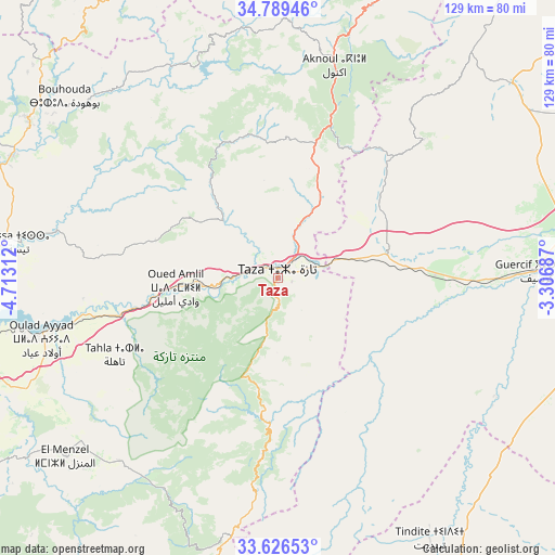
Taza GPS coordinates[2]
34° 12' 36" North, 4° 0' 36" West
| Map corner | latitude | longitude |
|---|---|---|
| Upper-left | 34.78946°, | -4.71312° |
| Center: | 34.21°, | -4.01° |
| Lower-right: | 33.62653°, | -3.30687° |
| Map W x H: | 129.3×129.3 km | = 80.3×80.3mi |
| max Lat: | 35.84906° ⇑31.4% North |
| Taza: | 34.21° |
| min Lat: | ⇓68.6% South 22.6558° |
| min Long | Taza | max Long |
| -15.60719° | -4.01° | -1.22855° |
| W 86.8%⇐ | ⇒13.2% E |
Elevation
Elevation of Taza is 530 m = 1739 ft, and this is 86.8 m = 285 ft below average elevation for this country.
| Max E: |
2637 m = 8652 ft | 47.3% |
| Avg. | 616.8 m = 2024 ft | |
| Taza | 530 m = 1739 ft | |
Min E: |
1 m = 3 ft | 52.7% |
See also: Taza elevation on elevation.city.
Geographical zone
Taza is located in North temperate zone (between Tropic of Cancer and the Arctic Circle). Distance of this Northern Tropic circle is 1197.9 km =744.3 mi to South.| Distance of | km | miles | from Taza |
|---|---|---|---|
| North Pole | 6203.3 | 3854.6 | to North |
| Arctic Circle | 3597.4 | 2235.3 | to North |
| Tropic Cancer | 1197.9 | 744.3 | to South |
| Equator | 3803.8 | 2363.6 | to South |


Nearby cities:
15 places around Taza: (largest is in red/bold)
• Ajdir
59.4 km =36.9 mi,  3°
3°
• Aknoul
51 km =31.7 mi,  14°
14°
• Bouarouss
75.4 km =46.9 mi,  282°
282°
• Galaz
81.8 km =50.8 mi,  297°
297°
• Guercif
60.4 km =37.5 mi,  88°
88°
• Matmata
51.4 km =31.9 mi,  256°
256°
• Oued Amlil
24.9 km =15.5 mi,  267°
267°
• Oulad Daoud
66.4 km =41.3 mi,  288°
288°
• Tahla
41.9 km =26 mi,  244°
244°
• Talzemt
70.9 km =44.1 mi,  193°
193°
• Taounate
68.3 km =42.4 mi, 302°
• Tazarine
39.8 km =24.7 mi,  204°
204°
• Timezgana
77.8 km =48.3 mi, 301°
• Tissa
60.7 km =37.7 mi, 278°
• Tmourghout
33.8 km =21 mi,  182°
182°
Sources, notices
• [Note1] Compared only with cities in Morocco existing in our database
• [Src1] Map data: © OpenStreetMap contributors (CC-BY-SA)
• [Src2] Other city data from geonames.org with taken over terms of usage.
• [Src3] Geographical zone / Annual Mean Temperature by Robert A. Rohde @ Wikipedia
