Azla geodata
Azla (Tanger-Tetouan-Al Hoceima) is a seat of a third-order administrative division; located in Morocco in Africa/Casablanca (GMT+1) time zone. In our database, there are 108 cities with bigger population. Compared to other cities in Morocco, 96.9% of cities are located further ↓South; 66.3% of cities are located further ←West and 97.3% of cities have higher elevation than Azla. Note1


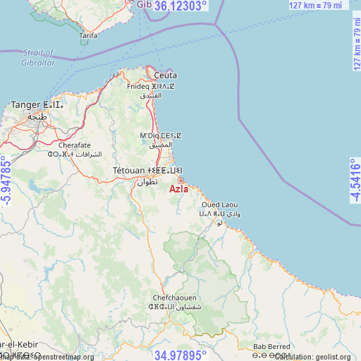
Azla GPS coordinates[2]
35° 33' 10.908" North, 5° 14' 40.992" West
| Map corner | latitude | longitude |
|---|---|---|
| Upper-left | 36.12303°, | -5.94785° |
| Center: | 35.55303°, | -5.24472° |
| Lower-right: | 34.97895°, | -4.5416° |
| Map W x H: | 127.2×127.2 km | = 79×79mi |
| max Lat: | 35.84906° ⇑3.1% North |
| Azla: | 35.55303° |
| min Lat: | ⇓96.9% South 22.6558° |
| min Long | Azla | max Long |
| -15.60719° | -5.24472° | -1.22855° |
| W 66.3%⇐ | ⇒33.7% E |
Elevation
Elevation of Azla is 9 m = 30 ft, and this is 607.8 m = 1994 ft below average elevation for this country.
| Max E: |
2637 m = 8652 ft | 97.3% |
| Avg. | 616.8 m = 2024 ft | |
| Azla | 9 m = 30 ft | |
Min E: |
1 m = 3 ft | 2.7% |
See also: Morocco elevation on elevation.city.
Geographical zone
Azla is located in North temperate zone (between Tropic of Cancer and the Arctic Circle). Distance of this Northern Tropic circle is 1347.2 km =837.1 mi to South.| Distance of | km | miles | from Azla |
|---|---|---|---|
| North Pole | 6053.9 | 3761.7 | to North |
| Arctic Circle | 3448 | 2142.5 | to North |
| Tropic Cancer | 1347.2 | 837.1 | to South |
| Equator | 3953.1 | 2456.3 | to South |


Nearby cities:
15 places around Azla: (largest is in red/bold)
• Bab Taza
54.8 km =34.1 mi,  175°
175°
• Cap Negro II
12.4 km =7.7 mi,  342°
342°
• Chefchaouene
42.8 km =26.6 mi, 182°
• Dar Chaoui
42.8 km =26.6 mi,  267°
267°
• Derdara
49.4 km =30.7 mi, 184°
• Fnidek
34.5 km =21.4 mi, 342°
• Mahroun
56.7 km =35.2 mi, 178°
• Martil
7.6 km =4.7 mi, 338°
• Mdiq
16.3 km =10.1 mi,  332°
332°
• Oued Laou
17.8 km =11.1 mi,  130°
130°
• Saddina
19.9 km =12.4 mi,  289°
289°
• Tangier
55.5 km =34.5 mi,  295°
295°
• Tizgane
22.4 km =13.9 mi, 134°
• Tétouan
11.5 km =7.1 mi,  284°
284°
• Zinat
19.6 km =12.2 mi,  225°
225°
Sources, notices
• [Note1] Compared only with cities in Morocco existing in our database
• [Src1] Map data: © OpenStreetMap contributors (CC-BY-SA)
• [Src2] Other city data from geonames.org with taken over terms of usage.
• [Src3] Geographical zone / Annual Mean Temperature by Robert A. Rohde @ Wikipedia
