Mdiq geodata
Mdiq (Tanger-Tetouan-Al Hoceima) is a seat of a second-order administrative division; located in Morocco in Africa/Casablanca (GMT+1) time zone. In our database, there are 108 cities with bigger population. Compared to other cities in Morocco, 98.8% of cities are located further ↓South; 62.8% of cities are located further ←West and 90.3% of cities have higher elevation than Mdiq. Note1


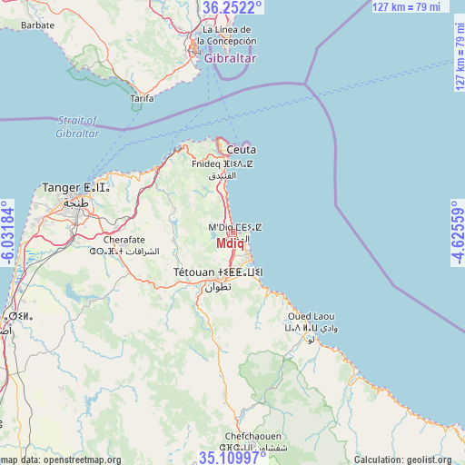
Mdiq GPS coordinates[2]
35° 40' 59.268" North, 5° 19' 43.356" West
| Map corner | latitude | longitude |
|---|---|---|
| Upper-left | 36.2522°, | -6.03184° |
| Center: | 35.68313°, | -5.32871° |
| Lower-right: | 35.10997°, | -4.62559° |
| Map W x H: | 127×127 km | = 78.9×78.9mi |
| max Lat: | 35.84906° ⇑1.2% North |
| Mdiq: | 35.68313° |
| min Lat: | ⇓98.8% South 22.6558° |
| min Long | Mdiq | max Long |
| -15.60719° | -5.32871° | -1.22855° |
| W 62.8%⇐ | ⇒37.2% E |
Elevation
Elevation of Mdiq is 23 m = 75 ft, and this is 593.8 m = 1948 ft below average elevation for this country.
| Max E: |
2637 m = 8652 ft | 90.3% |
| Avg. | 616.8 m = 2024 ft | |
| Mdiq | 23 m = 75 ft | |
Min E: |
1 m = 3 ft | 9.7% |
See also: Morocco elevation on elevation.city.
Geographical zone
Mdiq is located in North temperate zone (between Tropic of Cancer and the Arctic Circle). Distance of this Northern Tropic circle is 1361.7 km =846.1 mi to South.| Distance of | km | miles | from Mdiq |
|---|---|---|---|
| North Pole | 6039.5 | 3752.8 | to North |
| Arctic Circle | 3433.6 | 2133.5 | to North |
| Tropic Cancer | 1361.7 | 846.1 | to South |
| Equator | 3967.6 | 2465.4 | to South |


Nearby cities:
15 places around Mdiq: (largest is in red/bold)
• Asilah
68.2 km =42.4 mi,  249°
249°
• Azla
16.3 km =10.1 mi,  152°
152°
• Boukhalef
51.8 km =32.2 mi,  276°
276°
• Cap Negro II
4.7 km =2.9 mi,  123°
123°
• Chefchaouene
57.5 km =35.7 mi,  174°
174°
• Dar Chaoui
38.7 km =24 mi, 245°
• Derdara
63.8 km =39.6 mi,  176°
176°
• Fnidek
18.6 km =11.6 mi,  351°
351°
• Martil
8.8 km =5.5 mi, 146°
• Oued Laou
33.5 km =20.8 mi,  141°
141°
• Saddina
13.5 km =8.4 mi,  235°
235°
• Tangier
43.5 km =27 mi, 282°
• Tizgane
38.2 km =23.7 mi, 141°
• Tétouan
12.2 km =7.6 mi,  197°
197°
• Zinat
28.9 km =18 mi,  192°
192°
Sources, notices
• [Note1] Compared only with cities in Morocco existing in our database
• [Src1] Map data: © OpenStreetMap contributors (CC-BY-SA)
• [Src2] Other city data from geonames.org with taken over terms of usage.
• [Src3] Geographical zone / Annual Mean Temperature by Robert A. Rohde @ Wikipedia
