Chefchaouene geodata
Chefchaouene (Tanger-Tetouan-Al Hoceima) is a seat of a second-order administrative division; located in Morocco in Africa/Casablanca (GMT+1) time zone. With population of 36,280 people, there are 62 cities with bigger population in this country. Compared to other cities in Morocco, 93.4% of cities are located further ↓South; 65.5% of cities are located further ←West and 58.5% of cities have lower elevation than Chefchaouene. Note1


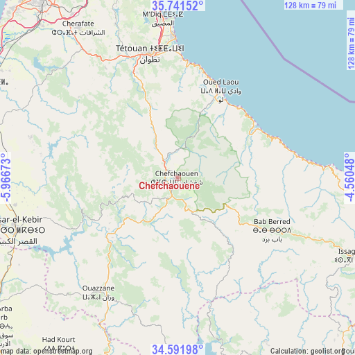
Chefchaouene GPS coordinates[2]
35° 10' 7.608" North, 5° 15' 48.96" West
| Map corner | latitude | longitude |
|---|---|---|
| Upper-left | 35.74152°, | -5.96673° |
| Center: | 35.16878°, | -5.2636° |
| Lower-right: | 34.59198°, | -4.56048° |
| Map W x H: | 127.8×127.8 km | = 79.4×79.4mi |
| max Lat: | 35.84906° ⇑6.6% North |
| Chefchaouene: | 35.16878° |
| min Lat: | ⇓93.4% South 22.6558° |
| min Long | Chefchaouene | max Long |
| -15.60719° | -5.2636° | -1.22855° |
| W 65.5%⇐ | ⇒34.5% E |
Elevation
Elevation of Chefchaouene is 607 m = 1991 ft, and this is 9.8 m = 32 ft below average elevation for this country.
| Max E: |
2637 m = 8652 ft | 41.5% |
| Avg. | 616.8 m = 2024 ft | |
| Chefchaouene | 607 m = 1991 ft | |
Min E: |
1 m = 3 ft | 58.5% |
See also: Morocco elevation on elevation.city.
Geographical zone
Chefchaouene is located in North temperate zone (between Tropic of Cancer and the Arctic Circle). Distance of this Northern Tropic circle is 1304.5 km =810.6 mi to South.| Distance of | km | miles | from Chefchaouene |
|---|---|---|---|
| North Pole | 6096.7 | 3788.3 | to North |
| Arctic Circle | 3490.8 | 2169.1 | to North |
| Tropic Cancer | 1304.5 | 810.6 | to South |
| Equator | 3910.4 | 2429.8 | to South |


Nearby cities:
15 places around Chefchaouene: (largest is in red/bold)
• Azla
42.8 km =26.6 mi,  2°
2°
• Bab Taza
13.3 km =8.3 mi,  153°
153°
• Brikcha
36 km =22.4 mi,  231°
231°
• Derdara
6.9 km =4.3 mi,  200°
200°
• Fifi
24.5 km =15.2 mi,  176°
176°
• Mahroun
14.2 km =8.8 mi,  168°
168°
• Martil
49.8 km =30.9 mi,  358°
358°
• Oued Laou
34.6 km =21.5 mi,  26°
26°
• Ouezzane
50.4 km =31.3 mi,  214°
214°
• Tabouda
51.2 km =31.8 mi, 167°
• Tamorot
51.1 km =31.8 mi,  120°
120°
• Tizgane
32.3 km =20.1 mi, 33°
• Tétouan
46.5 km =28.9 mi,  348°
348°
• Zinat
31.6 km =19.6 mi,  336°
336°
• Zoumi
41.3 km =25.7 mi,  190°
190°
In other languages:
- In Spanish: Xauen
- In France: Ville de Chechaouèn, Chefchaouen, Chefchaouene
- In Russian: Шефшауен
Sources, notices
• [Note1] Compared only with cities in Morocco existing in our database
• [Src1] Map data: © OpenStreetMap contributors (CC-BY-SA)
• [Src2] Other city data from geonames.org with taken over terms of usage.
• [Src3] Geographical zone / Annual Mean Temperature by Robert A. Rohde @ Wikipedia
