Fnidek geodata
Fnidek (Tanger-Tetouan-Al Hoceima) is a populated place; located in Morocco in Africa/Casablanca (GMT+1) time zone. With population of 53,559 people, there are 49 cities with bigger population in this country. Compared to other cities in Morocco, 100% of cities are located further ↓South; 61.6% of cities are located further ←West and 91.1% of cities have higher elevation than Fnidek. Note1


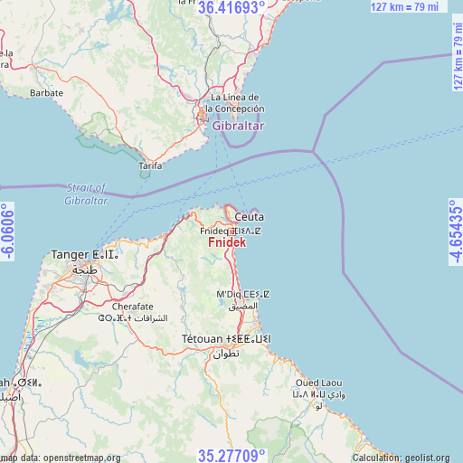
Fnidek GPS coordinates[2]
35° 50' 56.616" North, 5° 21' 26.892" West
| Map corner | latitude | longitude |
|---|---|---|
| Upper-left | 36.41693°, | -6.0606° |
| Center: | 35.84906°, | -5.35747° |
| Lower-right: | 35.27709°, | -4.65435° |
| Map W x H: | 126.7×126.7 km | = 78.7×78.7mi |
| max Lat: | 35.84906° ⇑0% North |
| Fnidek: | 35.84906° |
| min Lat: | ⇓100% South 22.6558° |
| min Long | Fnidek | max Long |
| -15.60719° | -5.35747° | -1.22855° |
| W 61.6%⇐ | ⇒38.4% E |
Elevation
Elevation of Fnidek is 21 m = 69 ft, and this is 595.8 m = 1955 ft below average elevation for this country.
| Max E: |
2637 m = 8652 ft | 91.1% |
| Avg. | 616.8 m = 2024 ft | |
| Fnidek | 21 m = 69 ft | |
Min E: |
1 m = 3 ft | 8.9% |
See also: Fnidek elevation on elevation.city.
Geographical zone
Fnidek is located in North temperate zone (between Tropic of Cancer and the Arctic Circle). Distance of this Northern Tropic circle is 1380.1 km =857.6 mi to South.| Distance of | km | miles | from Fnidek |
|---|---|---|---|
| North Pole | 6021 | 3741.3 | to North |
| Arctic Circle | 3415.1 | 2122 | to North |
| Tropic Cancer | 1380.1 | 857.6 | to South |
| Equator | 3986 | 2476.8 | to South |


Nearby cities:
15 places around Fnidek: (largest is in red/bold)
• Asilah
74.6 km =46.4 mi,  235°
235°
• Azla
34.5 km =21.4 mi,  162°
162°
• Boukhalef
50.6 km =31.4 mi,  255°
255°
• Cap Negro II
22 km =13.7 mi, 162°
• Chefchaouene
76.1 km =47.3 mi,  173°
173°
• Dar Chaoui
47.5 km =29.5 mi,  223°
223°
• Derdara
82.4 km =51.2 mi,  175°
175°
• Martil
26.9 km =16.7 mi, 163°
• Mdiq
18.6 km =11.6 mi, 171°
• Oued Laou
50.4 km =31.3 mi,  152°
152°
• Saddina
27.5 km =17.1 mi,  198°
198°
• Tangier
40.9 km =25.4 mi, 257°
• Tizgane
55.2 km =34.3 mi, 151°
• Tétouan
30.1 km =18.7 mi, 181°
• Zinat
46.8 km =29.1 mi, 184°
Sources, notices
• [Note1] Compared only with cities in Morocco existing in our database
• [Src1] Map data: © OpenStreetMap contributors (CC-BY-SA)
• [Src2] Other city data from geonames.org with taken over terms of usage.
• [Src3] Geographical zone / Annual Mean Temperature by Robert A. Rohde @ Wikipedia
