Mahroun geodata
Mahroun is a populated place; located in Morocco in Africa/Casablanca (GMT+1) time zone. With population of 600 people, there are 106 cities with bigger population in this country. Compared to other cities in Morocco, 88.4% of cities are located further ↓South; 66.7% of cities are located further ←West and 70.5% of cities have lower elevation than Mahroun. Note1


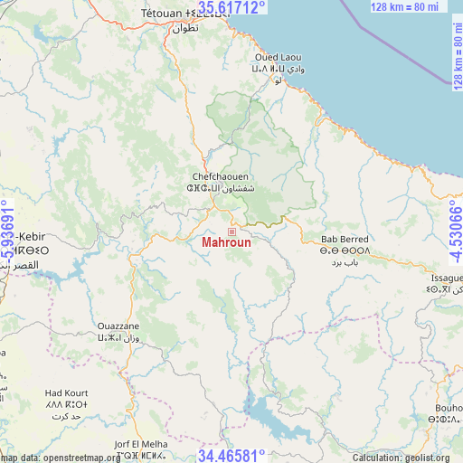
Mahroun GPS coordinates[2]
35° 2' 36.564" North, 5° 14' 1.608" West
| Map corner | latitude | longitude |
|---|---|---|
| Upper-left | 35.61712°, | -5.93691° |
| Center: | 35.04349°, | -5.23378° |
| Lower-right: | 34.46581°, | -4.53066° |
| Map W x H: | 128×128 km | = 79.5×79.5mi |
| max Lat: | 35.84906° ⇑11.6% North |
| Mahroun: | 35.04349° |
| min Lat: | ⇓88.4% South 22.6558° |
| min Long | Mahroun | max Long |
| -15.60719° | -5.23378° | -1.22855° |
| W 66.7%⇐ | ⇒33.3% E |
Elevation
Elevation of Mahroun is 910 m = 2986 ft, and this is 293.2 m = 962 ft above average elevation for this country.
| Max E: |
2637 m = 8652 ft | 29.5% |
| Mahroun | 910 m 2986 ft | |
| Avg. | 616.8 m = 2024 ft | |
Min E: |
1 m = 3 ft | 70.5% |
See also: Morocco elevation on elevation.city.
Geographical zone
Mahroun is located in North temperate zone (between Tropic of Cancer and the Arctic Circle). Distance of this Northern Tropic circle is 1290.6 km =801.9 mi to South.| Distance of | km | miles | from Mahroun |
|---|---|---|---|
| North Pole | 6110.6 | 3796.9 | to North |
| Arctic Circle | 3504.7 | 2177.7 | to North |
| Tropic Cancer | 1290.6 | 801.9 | to South |
| Equator | 3896.5 | 2421.2 | to South |


Nearby cities:
15 places around Mahroun: (largest is in red/bold)
• Bab Taza
3.8 km =2.4 mi,  57°
57°
• Brikcha
32 km =19.9 mi,  254°
254°
• Chefchaouene
14.2 km =8.8 mi,  348°
348°
• Derdara
9 km =5.6 mi,  325°
325°
• Fifi
10.6 km =6.6 mi,  186°
186°
• Oued Laou
46.7 km =29 mi,  15°
15°
• Ouezzane
41.8 km =26 mi,  228°
228°
• Ratba
39.9 km =24.8 mi,  137°
137°
• Sidi Redouane
44.1 km =27.4 mi,  205°
205°
• Tabouda
37 km =23 mi,  166°
166°
• Tamorot
43.1 km =26.8 mi,  106°
106°
• Teroual
41.2 km =25.6 mi, 185°
• Tizgane
43.7 km =27.2 mi, 20°
• Zinat
45.5 km =28.3 mi,  340°
340°
• Zoumi
28.6 km =17.8 mi,  200°
200°
Sources, notices
• [Note1] Compared only with cities in Morocco existing in our database
• [Src1] Map data: © OpenStreetMap contributors (CC-BY-SA)
• [Src2] Other city data from geonames.org with taken over terms of usage.
• [Src3] Geographical zone / Annual Mean Temperature by Robert A. Rohde @ Wikipedia
