Hell-Ville geodata
Hell-Ville (Diana) is a populated place; located in Madagascar in Indian/Antananarivo (GMT+3) time zone. With population of 22,680 people, there are 55 cities with bigger population in this country. Compared to other cities in Madagascar, 95.9% of cities are located further ↓South; 71.5% of cities are located further ←West and 74.8% of cities have higher elevation than Hell-Ville. Note1
Administrative division(s):
- Level 1: Diana
- Level 2: Nosy Be
- Level 3: Hell-Ville
- Level 4: La Batterie


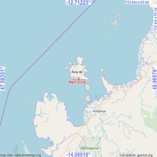
Hell-Ville GPS coordinates[2]
13° 23' 49.848" South, 48° 15' 59.868" East
| Map corner | latitude | longitude |
|---|---|---|
| Upper-left | -12.71223°, | 47.56351° |
| Center: | -13.39718°, | 48.26663° |
| Lower-right: | -14.08018°, | 48.96976° |
| Map W x H: | 152.1×152.1 km | = 94.5×94.5mi |
| max Lat: | -12.31732° ⇑4.1% North |
| Hell-Ville: | -13.39718° |
| min Lat: | ⇓95.9% South -25.3° |
| min Long | Hell-Ville | max Long |
| 43.65° | 48.26663° | 50.27876° |
| W 71.5%⇐ | ⇒28.5% E |
Elevation
Elevation of Hell-Ville is 23 m = 75 ft, and this is 534.4 m = 1753 ft below average elevation for this country.
| Max E: |
1763 m = 5784 ft | 74.8% |
| Avg. | 557.4 m = 1829 ft | |
| Hell-Ville | 23 m = 75 ft | |
Min E: |
1 m = 3 ft | 25.2% |
See also: Madagascar elevation on elevation.city.
Geographical zone
Hell-Ville is located in South Torrid zone (between Equator and Tropic of Capricorn). Distance of this Southern Tropic circle is 1116.3 km =693.6 mi to South.| Distance of | km | miles | from Hell-Ville |
|---|---|---|---|
| Equator | 1489.6 | 925.6 | to North |
| Tropic Capricorn | 1116.3 | 693.6 | to South |
| Antarctic Circle | 5911.5 | 3673.2 | to South |
| South Pole | 8517.4 | 5292.5 | to South |


Nearby cities:
15 places around Hell-Ville: (largest is in red/bold)
• Ambanja
36.3 km =22.6 mi,  146°
146°
• Ambarakaraka
65.9 km =40.9 mi,  99°
99°
• Ambilobe
87.6 km =54.4 mi,  75°
75°
• Ambodivoara
212.5 km =132 mi,  119°
119°
• Ampahana
258.6 km =160.7 mi,  125°
125°
• Andapa
204.1 km =126.8 mi, 133°
• Antakotako
269.9 km =167.7 mi,  142°
142°
• Antalaha
273.9 km =170.2 mi, 127°
• Antsiranana
163.6 km =101.7 mi,  42°
42°
• Antsohihy
167.6 km =104.1 mi,  190°
190°
• Antsohimbondrona
72.1 km =44.8 mi,  61°
61°
• Bealanana
137.7 km =85.6 mi,  157°
157°
• Mahalina
113 km =70.2 mi,  31°
31°
• Sadjoavato
146 km =90.7 mi,  53°
53°
• Sambava
226.8 km =140.9 mi, 115°
Sources, notices
• [Note1] Compared only with cities in Madagascar existing in our database
• [Src1] Map data: © OpenStreetMap contributors (CC-BY-SA)
• [Src2] Other city data from geonames.org with taken over terms of usage.
• [Src3] Geographical zone / Annual Mean Temperature by Robert A. Rohde @ Wikipedia
