Goundam geodata
Goundam (Tombouctou) is a seat of a second-order administrative division; located in Mali in Africa/Bamako (GMT+0) time zone. With population of 8,456 people, there are 28 cities with bigger population in this country. Compared to other cities in Mali, 85.2% of cities are located further ↓South; 72.1% of cities are located further ←West and 86.9% of cities have higher elevation than Goundam. Note1


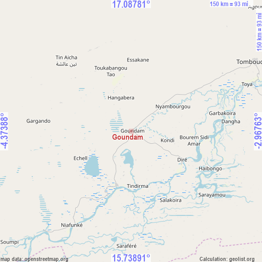
Goundam GPS coordinates[2]
16° 24' 52.308" North, 3° 40' 14.7" West
| Map corner | latitude | longitude |
|---|---|---|
| Upper-left | 17.08781°, | -4.37388° |
| Center: | 16.41453°, | -3.67075° |
| Lower-right: | 15.73891°, | -2.96763° |
| Map W x H: | 150×150 km | = 93.2×93.2mi |
| max Lat: | 22.67443° ⇑14.8% North |
| Goundam: | 16.41453° |
| min Lat: | ⇓85.2% South 10.55° |
| min Long | Goundam | max Long |
| -11.44448° | -3.67075° | 3.14111° |
| W 72.1%⇐ | ⇒27.9% E |
Elevation
Elevation of Goundam is 259 m = 850 ft, and this is 49 m = 161 ft below average elevation for this country.
| Max E: |
540 m = 1772 ft | 86.9% |
| Avg. | 308 m = 1010 ft | |
| Goundam | 259 m = 850 ft | |
Min E: |
39 m = 128 ft | 13.1% |
See also: Mali elevation on elevation.city.
Geographical zone
Goundam is located in North Torrid zone (between Equator and Tropic of Cancer). Distance of this Northern Tropic circle is 780.8 km =485.2 mi to North.| Distance of | km | miles | from Goundam |
|---|---|---|---|
| North Pole | 8181.9 | 5084 | to North |
| Arctic Circle | 5576 | 3464.8 | to North |
| Tropic Cancer | 780.8 | 485.2 | to North |
| Equator | 1825.1 | 1134.1 | to South |


Nearby cities:
15 places around Goundam: (largest is in red/bold)
• Araouane
277.3 km =172.3 mi,  3°
3°
• Bandiagara
229.6 km =142.7 mi,  178°
178°
• Bankass
260.4 km =161.8 mi, 176°
• Diré
33.7 km =20.9 mi,  121°
121°
• Djénné
294.6 km =183.1 mi,  198°
198°
• Douentza
175 km =108.7 mi,  153°
153°
• Gourma Rharous
193.2 km =120 mi,  74°
74°
• Koro
269 km =167.1 mi,  166°
166°
• Ké-Macina
327.1 km =203.3 mi,  213°
213°
• Mopti
221.5 km =137.6 mi,  194°
194°
• Niafunké
63.6 km =39.5 mi, 212°
• Sokolo
322.3 km =200.3 mi,  234°
234°
• Timbuktu
81.2 km =50.5 mi,  60°
60°
• Ténenkou
255.3 km =158.6 mi, 211°
• Youwarou
132.4 km =82.3 mi, 208°
Sources, notices
• [Note1] Compared only with cities in Mali existing in our database
• [Src1] Map data: © OpenStreetMap contributors (CC-BY-SA)
• [Src2] Other city data from geonames.org with taken over terms of usage.
• [Src3] Geographical zone / Annual Mean Temperature by Robert A. Rohde @ Wikipedia
