Sujji geodata
Sujji (Central Aimak) is a seat of a second-order administrative division; located in Mongolia in Asia/Ulaanbaatar (GMT+8) time zone. In our database, there are 33 cities with bigger population. Compared to other cities in Mongolia, 54.6% of cities are located further ↓South; 64.4% of cities are located further ←West and 84.4% of cities have higher elevation than Sujji. Note1


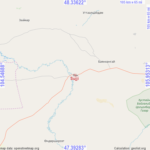
Sujji GPS coordinates[2]
47° 52' 0.012" North, 105° 15' 0" East
| Map corner | latitude | longitude |
|---|---|---|
| Upper-left | 48.33622°, | 104.54688° |
| Center: | 47.86667°, | 105.25° |
| Lower-right: | 47.39283°, | 105.95313° |
| Map W x H: | 104.9×104.9 km | = 65.2×65.2mi |
| max Lat: | 51.50725° ⇑45.4% North |
| Sujji: | 47.86667° |
| min Lat: | ⇓54.6% South 42.84199° |
| min Long | Sujji | max Long |
| 89.14358° | 105.25° | 118.51014° |
| W 64.4%⇐ | ⇒35.6% E |
Elevation
Elevation of Sujji is 1009 m = 3310 ft, and this is 407.5 m = 1337 ft below average elevation for this country.
| Max E: |
2800 m = 9186 ft | 84.4% |
| Avg. | 1416.5 m = 4647 ft | |
| Sujji | 1009 m = 3310 ft | |
Min E: |
619 m = 2031 ft | 15.6% |
See also: Mongolia elevation on elevation.city.
Geographical zone
Sujji is located in North temperate zone (between Tropic of Cancer and the Arctic Circle). Distance of this North polar circle is 2078.9 km =1291.8 mi to North.| Distance of | km | miles | from Sujji |
|---|---|---|---|
| North Pole | 4684.8 | 2911 | to North |
| Arctic Circle | 2078.9 | 1291.8 | to North |
| Tropic Cancer | 2716.4 | 1687.9 | to South |
| Equator | 5322.3 | 3307.1 | to South |


Nearby cities:
15 places around Sujji: (largest is in red/bold)
• Altanbulag
87.9 km =54.6 mi,  102°
102°
• Ar-Asgat
45.6 km =28.3 mi,  15°
15°
• Argalant
48.9 km =30.4 mi,  80°
80°
• Bat-Öldziyt
52.5 km =32.6 mi,  317°
317°
• Bayantöhöm
106.7 km =66.3 mi,  188°
188°
• Bayshint
59.6 km =37 mi,  212°
212°
• Bornuur
100.7 km =62.6 mi,  48°
48°
• Dashinchilling
89.5 km =55.6 mi,  268°
268°
• Dund-Urt
53.5 km =33.2 mi,  69°
69°
• Ihsüüj
87.1 km =54.1 mi,  62°
62°
• Jargalant
85.9 km =53.4 mi,  32°
32°
• Orgil
65.5 km =40.7 mi,  4°
4°
• Tsul-Ulaan
56.1 km =34.9 mi, 266°
• Ulaanhad
24.4 km =15.2 mi, 67°
• Ulaanhudag
81.7 km =50.8 mi,  223°
223°
Sources, notices
• [Note1] Compared only with cities in Mongolia existing in our database
• [Src1] Map data: © OpenStreetMap contributors (CC-BY-SA)
• [Src2] Other city data from geonames.org with taken over terms of usage.
• [Src3] Geographical zone / Annual Mean Temperature by Robert A. Rohde @ Wikipedia
