Javhlant geodata
Javhlant (Central Aimak) is a seat of a second-order administrative division; located in Mongolia in Asia/Ulaanbaatar (GMT+8) time zone. In our database, there are 33 cities with bigger population. Compared to other cities in Mongolia, 73% of cities are located further ↓South; 70.6% of cities are located further ←West and 91.4% of cities have higher elevation than Javhlant. Note1


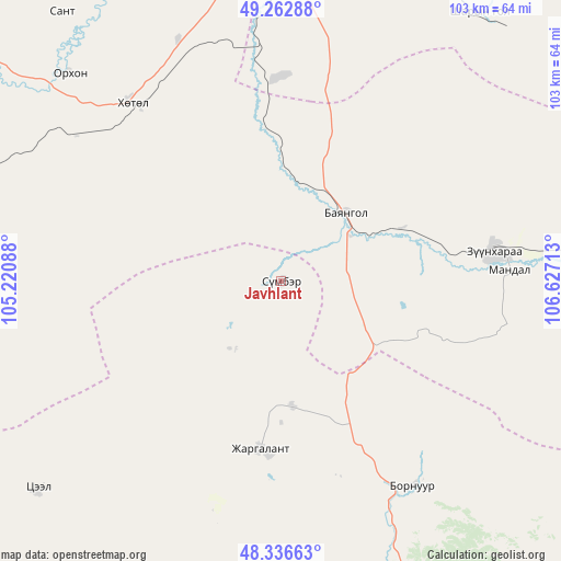
Javhlant GPS coordinates[2]
48° 48' 6.804" North, 105° 55' 26.4" East
| Map corner | latitude | longitude |
|---|---|---|
| Upper-left | 49.26288°, | 105.22088° |
| Center: | 48.80189°, | 105.924° |
| Lower-right: | 48.33663°, | 106.62713° |
| Map W x H: | 103×103 km | = 64×64mi |
| max Lat: | 51.50725° ⇑27% North |
| Javhlant: | 48.80189° |
| min Lat: | ⇓73% South 42.84199° |
| min Long | Javhlant | max Long |
| 89.14358° | 105.924° | 118.51014° |
| W 70.6%⇐ | ⇒29.4% E |
Elevation
Elevation of Javhlant is 864 m = 2835 ft, and this is 552.5 m = 1813 ft below average elevation for this country.
| Max E: |
2800 m = 9186 ft | 91.4% |
| Avg. | 1416.5 m = 4647 ft | |
| Javhlant | 864 m = 2835 ft | |
Min E: |
619 m = 2031 ft | 8.6% |
See also: Mongolia elevation on elevation.city.
Geographical zone
Javhlant is located in North temperate zone (between Tropic of Cancer and the Arctic Circle). Distance of this North polar circle is 1974.9 km =1227.1 mi to North.| Distance of | km | miles | from Javhlant |
|---|---|---|---|
| North Pole | 4580.8 | 2846.4 | to North |
| Arctic Circle | 1974.9 | 1227.1 | to North |
| Tropic Cancer | 2820.3 | 1752.5 | to South |
| Equator | 5426.3 | 3371.7 | to South |


Nearby cities:
15 places around Javhlant: (largest is in red/bold)
• Ar-Asgat
70.9 km =44.1 mi,  212°
212°
• Bornuur
45 km =28 mi,  145°
145°
• Darhan
76.1 km =47.3 mi,  359°
359°
• Dzüünharaa
39.5 km =24.5 mi,  81°
81°
• Dzüünkharaa
62.3 km =38.7 mi,  107°
107°
• Enhtal
63.8 km =39.6 mi,  320°
320°
• Hongor
47.7 km =29.6 mi, 357°
• Ihsüüj
69.6 km =43.2 mi,  157°
157°
• Jargalant
31.5 km =19.6 mi,  187°
187°
• Mandal
76.9 km =47.8 mi,  128°
128°
• Nart
54.6 km =33.9 mi,  314°
314°
• Nomgon
48.1 km =29.9 mi,  336°
336°
• Orgil
59 km =36.7 mi,  229°
229°
• Orhontuul
71.3 km =44.3 mi,  283°
283°
• Sharïngol
60.9 km =37.8 mi,  37°
37°
Sources, notices
• [Note1] Compared only with cities in Mongolia existing in our database
• [Src1] Map data: © OpenStreetMap contributors (CC-BY-SA)
• [Src2] Other city data from geonames.org with taken over terms of usage.
• [Src3] Geographical zone / Annual Mean Temperature by Robert A. Rohde @ Wikipedia
