Choyr geodata
Choyr (Govĭ-Sumber) is a seat of a first-order administrative division; located in Mongolia in Asia/Ulaanbaatar (GMT+8) time zone. With population of 9,895 people, there are 23 cities with bigger population in this country. Compared to other cities in Mongolia, 73% of cities are located further ↑North; 82.2% of cities are located further ←West and 58.3% of cities have higher elevation than Choyr. Note1


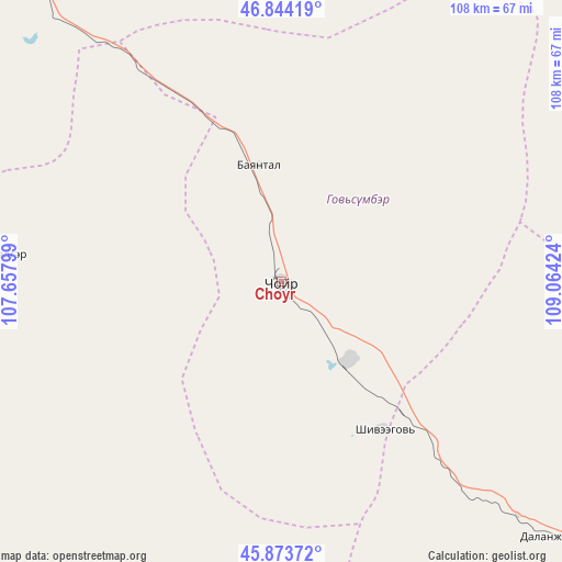
Choyr GPS coordinates[2]
46° 21' 39.996" North, 108° 21' 39.996" East
| Map corner | latitude | longitude |
|---|---|---|
| Upper-left | 46.84419°, | 107.65799° |
| Center: | 46.36111°, | 108.36111° |
| Lower-right: | 45.87372°, | 109.06424° |
| Map W x H: | 107.9×107.9 km | = 67×67mi |
| max Lat: | 51.50725° ⇑73% North |
| Choyr: | 46.36111° |
| min Lat: | ⇓27% South 42.84199° |
| min Long | Choyr | max Long |
| 89.14358° | 108.36111° | 118.51014° |
| W 82.2%⇐ | ⇒17.8% E |
Elevation
Elevation of Choyr is 1286 m = 4219 ft, and this is 130.5 m = 428 ft below average elevation for this country.
| Max E: |
2800 m = 9186 ft | 58.3% |
| Avg. | 1416.5 m = 4647 ft | |
| Choyr | 1286 m = 4219 ft | |
Min E: |
619 m = 2031 ft | 41.7% |
See also: Mongolia elevation on elevation.city.
Geographical zone
Choyr is located in North temperate zone (between Tropic of Cancer and the Arctic Circle). Distance of this North polar circle is 2246.3 km =1395.8 mi to North.| Distance of | km | miles | from Choyr |
|---|---|---|---|
| North Pole | 4852.2 | 3015 | to North |
| Arctic Circle | 2246.3 | 1395.8 | to North |
| Tropic Cancer | 2549 | 1583.9 | to South |
| Equator | 5154.9 | 3203.1 | to South |


Nearby cities:
15 places around Choyr: (largest is in red/bold)
• Argatay
72.2 km =44.9 mi,  203°
203°
• Avraga
110.6 km =68.7 mi,  34°
34°
• Bayantal
22.8 km =14.2 mi,  349°
349°
• Bayasgalant
91.3 km =56.7 mi,  355°
355°
• Böhöt
125.7 km =78.1 mi,  182°
182°
• Darhan
85.7 km =53.3 mi,  70°
70°
• Dzogsool
104.6 km =65 mi,  297°
297°
• Hajuu-Us
75.5 km =46.9 mi,  242°
242°
• Haraat
54.9 km =34.1 mi,  276°
276°
• Maanĭt
117.2 km =72.8 mi,  327°
327°
• Shiveegovĭ
34.7 km =21.6 mi,  144°
144°
• Tsagaandörvölj
96.8 km =60.1 mi,  130°
130°
• Tsant
127.9 km =79.5 mi,  261°
261°
• Tsomog
73.5 km =45.7 mi, 132°
• Ulaan-Ereg
121.8 km =75.7 mi,  60°
60°
Sources, notices
• [Note1] Compared only with cities in Mongolia existing in our database
• [Src1] Map data: © OpenStreetMap contributors (CC-BY-SA)
• [Src2] Other city data from geonames.org with taken over terms of usage.
• [Src3] Geographical zone / Annual Mean Temperature by Robert A. Rohde @ Wikipedia
