Shiveegovĭ geodata
Shiveegovĭ (Govĭ-Sumber) is a seat of a second-order administrative division; located in Mongolia in Asia/Ulaanbaatar (GMT+8) time zone. In our database, there are 33 cities with bigger population. Compared to other cities in Mongolia, 77.9% of cities are located further ↑North; 82.8% of cities are located further ←West and 69.3% of cities have higher elevation than Shiveegovĭ. Note1


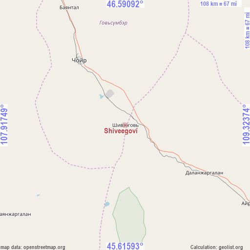
Shiveegovĭ GPS coordinates[2]
46° 6' 20.088" North, 108° 37' 14.196" East
| Map corner | latitude | longitude |
|---|---|---|
| Upper-left | 46.59092°, | 107.91749° |
| Center: | 46.10558°, | 108.62061° |
| Lower-right: | 45.61593°, | 109.32374° |
| Map W x H: | 108.4×108.4 km | = 67.4×67.4mi |
| max Lat: | 51.50725° ⇑77.9% North |
| Shiveegovĭ: | 46.10558° |
| min Lat: | ⇓22.1% South 42.84199° |
| min Long | Shiveegovĭ | max Long |
| 89.14358° | 108.62061° | 118.51014° |
| W 82.8%⇐ | ⇒17.2% E |
Elevation
Elevation of Shiveegovĭ is 1179 m = 3868 ft, and this is 237.5 m = 779 ft below average elevation for this country.
| Max E: |
2800 m = 9186 ft | 69.3% |
| Avg. | 1416.5 m = 4647 ft | |
| Shiveegovĭ | 1179 m = 3868 ft | |
Min E: |
619 m = 2031 ft | 30.7% |
See also: Mongolia elevation on elevation.city.
Geographical zone
Shiveegovĭ is located in North temperate zone (between Tropic of Cancer and the Arctic Circle). Distance of this North polar circle is 2274.7 km =1413.4 mi to North.| Distance of | km | miles | from Shiveegovĭ |
|---|---|---|---|
| North Pole | 4880.6 | 3032.7 | to North |
| Arctic Circle | 2274.7 | 1413.4 | to North |
| Tropic Cancer | 2520.5 | 1566.2 | to South |
| Equator | 5126.5 | 3185.5 | to South |


Nearby cities:
15 places around Shiveegovĭ: (largest is in red/bold)
• Argatay
62 km =38.5 mi,  232°
232°
• Avraga
127 km =78.9 mi,  20°
20°
• Bayan
120.1 km =74.6 mi,  82°
82°
• Bayantal
56.3 km =35 mi,  334°
334°
• Bayasgalant
122.5 km =76.1 mi,  347°
347°
• Böhöt
100.6 km =62.5 mi,  195°
195°
• Choyr
34.7 km =21.6 mi,  324°
324°
• Darhan
83.4 km =51.8 mi,  47°
47°
• Dzogsool
136.6 km =84.9 mi,  304°
304°
• Hajuu-Us
87.5 km =54.4 mi,  265°
265°
• Haraat
82.2 km =51.1 mi,  294°
294°
• Suugaant
137.7 km =85.6 mi,  242°
242°
• Tsagaandörvölj
63.9 km =39.7 mi,  122°
122°
• Tsomog
40.3 km =25 mi, 121°
• Ulaan-Ereg
123.6 km =76.8 mi,  44°
44°
Sources, notices
• [Note1] Compared only with cities in Mongolia existing in our database
• [Src1] Map data: © OpenStreetMap contributors (CC-BY-SA)
• [Src2] Other city data from geonames.org with taken over terms of usage.
• [Src3] Geographical zone / Annual Mean Temperature by Robert A. Rohde @ Wikipedia
