Bayasgalant geodata
Bayasgalant (Central Aimak) is a seat of a second-order administrative division; located in Mongolia in Asia/Ulaanbaatar (GMT+8) time zone. In our database, there are 33 cities with bigger population. Compared to other cities in Mongolia, 58.9% of cities are located further ↑North; 81.3% of cities are located further ←West and 51.2% of cities have higher elevation than Bayasgalant. Note1


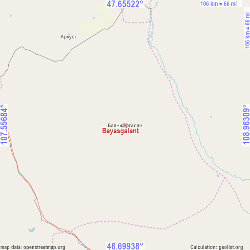
Bayasgalant GPS coordinates[2]
47° 10' 46.02" North, 108° 15' 35.856" East
| Map corner | latitude | longitude |
|---|---|---|
| Upper-left | 47.65522°, | 107.55684° |
| Center: | 47.17945°, | 108.25996° |
| Lower-right: | 46.69938°, | 108.96309° |
| Map W x H: | 106.3×106.3 km | = 66.1×66.1mi |
| max Lat: | 51.50725° ⇑58.9% North |
| Bayasgalant: | 47.17945° |
| min Lat: | ⇓41.1% South 42.84199° |
| min Long | Bayasgalant | max Long |
| 89.14358° | 108.25996° | 118.51014° |
| W 81.3%⇐ | ⇒18.7% E |
Elevation
Elevation of Bayasgalant is 1376 m = 4514 ft, and this is 40.5 m = 133 ft below average elevation for this country.
| Max E: |
2800 m = 9186 ft | 51.2% |
| Avg. | 1416.5 m = 4647 ft | |
| Bayasgalant | 1376 m = 4514 ft | |
Min E: |
619 m = 2031 ft | 48.8% |
See also: Mongolia elevation on elevation.city.
Geographical zone
Bayasgalant is located in North temperate zone (between Tropic of Cancer and the Arctic Circle). Distance of this North polar circle is 2155.3 km =1339.2 mi to North.| Distance of | km | miles | from Bayasgalant |
|---|---|---|---|
| North Pole | 4761.2 | 2958.5 | to North |
| Arctic Circle | 2155.3 | 1339.2 | to North |
| Tropic Cancer | 2639.9 | 1640.4 | to South |
| Equator | 5245.9 | 3259.7 | to South |


Nearby cities:
15 places around Bayasgalant: (largest is in red/bold)
• Arhust
74 km =46 mi,  337°
337°
• Avraga
70.3 km =43.7 mi,  90°
90°
• Bayandelger
61.9 km =38.5 mi,  349°
349°
• Bayantal
68.7 km =42.7 mi,  177°
177°
• Bulag
114.7 km =71.3 mi,  8°
8°
• Choyr
91.3 km =56.7 mi, 175°
• Darhan
107.9 km =67 mi,  125°
125°
• Dzogsool
94.2 km =58.5 mi,  243°
243°
• Dzuunmod
114.5 km =71.1 mi,  300°
300°
• Haraat
96.7 km =60.1 mi,  208°
208°
• Höshigiyn-Ar
106.3 km =66.1 mi,  293°
293°
• Maanĭt
55.4 km =34.4 mi,  278°
278°
• Modot
86.9 km =54 mi,  43°
43°
• Ulaan-Ereg
117.1 km =72.8 mi,  105°
105°
• Зуунмод
114.5 km =71.1 mi, 300°
Sources, notices
• [Note1] Compared only with cities in Mongolia existing in our database
• [Src1] Map data: © OpenStreetMap contributors (CC-BY-SA)
• [Src2] Other city data from geonames.org with taken over terms of usage.
• [Src3] Geographical zone / Annual Mean Temperature by Robert A. Rohde @ Wikipedia
