Tsagaanhayrhan geodata
Tsagaanhayrhan (Uvs) is a seat of a second-order administrative division; located in Mongolia in Asia/Hovd (GMT+7) time zone. In our database, there are 33 cities with bigger population. Compared to other cities in Mongolia, 85.3% of cities are located further ↓South; 86.2% of cities are located further →East and 81% of cities have lower elevation than Tsagaanhayrhan. Note1


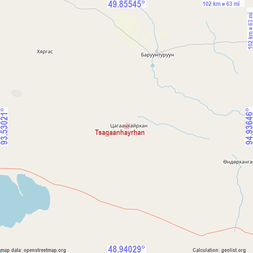
Tsagaanhayrhan GPS coordinates[2]
49° 24' 0" North, 94° 13' 59.988" East
| Map corner | latitude | longitude |
|---|---|---|
| Upper-left | 49.85545°, | 93.53021° |
| Center: | 49.4°, | 94.23333° |
| Lower-right: | 48.94029°, | 94.93646° |
| Map W x H: | 101.8×101.8 km | = 63.3×63.3mi |
| max Lat: | 51.50725° ⇑14.7% North |
| Tsagaanhayrhan: | 49.4° |
| min Lat: | ⇓85.3% South 42.84199° |
| min Long | Tsagaanhayrhan | max Long |
| 89.14358° | 94.23333° | 118.51014° |
| W 13.8%⇐ | ⇒86.2% E |
Elevation
Elevation of Tsagaanhayrhan is 1804 m = 5919 ft, and this is 387.5 m = 1271 ft above average elevation for this country.
| Max E: |
2800 m = 9186 ft | 19% |
| Tsagaanhayrhan | 1804 m 5919 ft | |
| Avg. | 1416.5 m = 4647 ft | |
Min E: |
619 m = 2031 ft | 81% |
See also: Mongolia elevation on elevation.city.
Geographical zone
Tsagaanhayrhan is located in North temperate zone (between Tropic of Cancer and the Arctic Circle). Distance of this North polar circle is 1908.4 km =1185.8 mi to North.| Distance of | km | miles | from Tsagaanhayrhan |
|---|---|---|---|
| North Pole | 4514.3 | 2805.1 | to North |
| Arctic Circle | 1908.4 | 1185.8 | to North |
| Tropic Cancer | 2886.8 | 1793.8 | to South |
| Equator | 5492.8 | 3413.1 | to South |


Nearby cities:
15 places around Tsagaanhayrhan: (largest is in red/bold)
• Altanbulag
153.1 km =95.1 mi,  93°
93°
• Baruunturuun
31.4 km =19.5 mi,  23°
23°
• Bugat
33.6 km =20.9 mi,  296°
296°
• Dzel
64.9 km =40.3 mi,  330°
330°
• Dzür
116.2 km =72.2 mi,  75°
75°
• Holboo
125.7 km =78.1 mi,  135°
135°
• Hungiy
98.3 km =61.1 mi,  177°
177°
• Jargalant
88.6 km =55.1 mi,  96°
96°
• Naranbulag
120.7 km =75 mi,  268°
268°
• Nuga
136.7 km =84.9 mi,  151°
151°
• Sharbulag
104.9 km =65.2 mi,  231°
231°
• Tegsh
147.5 km =91.7 mi,  119°
119°
• Tooromt
127.4 km =79.2 mi,  338°
338°
• Tsalgar
78.1 km =48.5 mi, 296°
• Tsetserleg
47.5 km =29.5 mi,  107°
107°
Sources, notices
• [Note1] Compared only with cities in Mongolia existing in our database
• [Src1] Map data: © OpenStreetMap contributors (CC-BY-SA)
• [Src2] Other city data from geonames.org with taken over terms of usage.
• [Src3] Geographical zone / Annual Mean Temperature by Robert A. Rohde @ Wikipedia
