Atar geodata
Atar (Adrar) is a seat of a first-order administrative division; located in Mauritania in Africa/Nouakchott (GMT+0) time zone. With population of 24,021 people, there are 7 cities with bigger population in this country. Compared to other cities in Mauritania, 89.5% of cities are located further ↓South; 57.9% of cities are located further ←West and 73.7% of cities have lower elevation than Atar. Note1


Atar GPS coordinates[2]
20° 31' 3.72" North, 13° 2' 54.852" West
| Map corner | latitude | longitude |
|---|---|---|
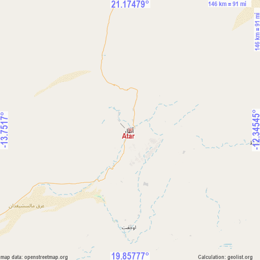
| Upper-left | 21.17479°, | -13.7517° |
| Center: | 20.5177°, | -13.04857° |
| Lower-right: | 19.85777°, | -12.34545° |
| Map W x H: | 146.4×146.4 km | = 91×91mi |
| max Lat: | 22.73542° ⇑10.5% North |
| Atar: | 20.5177° |
| min Lat: | ⇓89.5% South 15.15846° |
| min Long | Atar | max Long |
| -17.03842° | -13.04857° | -7.25649° |
| W 57.9%⇐ | ⇒42.1% E |
Elevation
Elevation of Atar is 224 m = 735 ft, and this is 97.9 m = 321 ft above average elevation for this country.
| Max E: |
500 m = 1640 ft | 26.3% |
| Atar | 224 m 735 ft | |
| Avg. | 126.1 m = 414 ft | |
Min E: |
1 m = 3 ft | 73.7% |
See also: Mauritania elevation on elevation.city.
Geographical zone
Atar is located in North Torrid zone (between Equator and Tropic of Cancer). Distance of this Northern Tropic circle is 324.6 km =201.7 mi to North.| Distance of | km | miles | from Atar |
|---|---|---|---|
| North Pole | 7725.7 | 4800.5 | to North |
| Arctic Circle | 5119.8 | 3181.3 | to North |
| Tropic Cancer | 324.6 | 201.7 | to North |
| Equator | 2281.4 | 1417.6 | to South |


Nearby cities:
11 places around Atar: (largest is in red/bold)
• Akjoujt
163.8 km =101.8 mi,  238°
238°
• Aleg
395.8 km =245.9 mi,  193°
193°
• Arafat
411.8 km =255.9 mi,  228°
228°
• Barkéwol
435 km =270.3 mi,  172°
172°
• Chingueṭṭi
71.8 km =44.6 mi,  94°
94°
• Dar Naim
403.7 km =250.8 mi, 228°
• Nouakchott
409.4 km =254.4 mi, 228°
• Tevragh Zeina
409.2 km =254.3 mi, 228°
• Tidjikja
276.4 km =171.7 mi,  142°
142°
• Zouerate
253.7 km =157.6 mi,  13°
13°
• ’Elb el Jmel
401.9 km =249.7 mi, 193°
Sources, notices
• [Note1] Compared only with cities in Mauritania existing in our database
• [Src1] Map data: © OpenStreetMap contributors (CC-BY-SA)
• [Src2] Other city data from geonames.org with taken over terms of usage.
• [Src3] Geographical zone / Annual Mean Temperature by Robert A. Rohde @ Wikipedia
