’Elb el Jmel geodata
’Elb el Jmel (Brakna) is a populated locality; located in Mauritania in Africa/Nouakchott (GMT+0) time zone. With population of 1,500 people, there are 15 cities with bigger population in this country. Compared to other cities in Mauritania, 57.9% of cities are located further ↑North; 57.9% of cities are located further →East and 52.6% of cities have higher elevation than ’Elb el Jmel. Note1


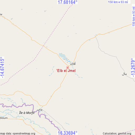
’Elb el Jmel GPS coordinates[2]
17° 0' 37.8" North, 13° 58' 15.672" West
| Map corner | latitude | longitude |
|---|---|---|
| Upper-left | 17.68164°, | -14.67415° |
| Center: | 17.0105°, | -13.97102° |
| Lower-right: | 16.33694°, | -13.2679° |
| Map W x H: | 149.5×149.5 km | = 92.9×92.9mi |
| max Lat: | 22.73542° ⇑57.9% North |
| ’Elb el Jmel: | 17.0105° |
| min Lat: | ⇓42.1% South 15.15846° |
| min Long | ’Elb el Jmel | max Long |
| -17.03842° | -13.97102° | -7.25649° |
| W 42.1%⇐ | ⇒57.9% E |
Elevation
Elevation of ’Elb el Jmel is 44 m = 144 ft, and this is 82.1 m = 269 ft below average elevation for this country.
| Max E: |
500 m = 1640 ft | 52.6% |
| Avg. | 126.1 m = 414 ft | |
| ’Elb el Jmel | 44 m = 144 ft | |
Min E: |
1 m = 3 ft | 47.4% |
See also: Mauritania elevation on elevation.city.
Geographical zone
’Elb el Jmel is located in North Torrid zone (between Equator and Tropic of Cancer). Distance of this Northern Tropic circle is 714.5 km =444 mi to North.| Distance of | km | miles | from ’Elb el Jmel |
|---|---|---|---|
| North Pole | 8115.7 | 5042.9 | to North |
| Arctic Circle | 5509.8 | 3423.6 | to North |
| Tropic Cancer | 714.5 | 444 | to North |
| Equator | 1891.4 | 1175.3 | to South |


Nearby cities:
15 places around ’Elb el Jmel: (largest is in red/bold)
• Akjoujt
307.3 km =190.9 mi,  351°
351°
• Aleg
7.8 km =4.8 mi,  52°
52°
• Arafat
241.4 km =150 mi,  298°
298°
• Atar
401.9 km =249.7 mi,  13°
13°
• Barkéwol
162 km =100.7 mi,  104°
104°
• Chingueṭṭi
419.6 km =260.7 mi,  23°
23°
• Dar Naim
240.6 km =149.5 mi, 300°
• Kaédi
107.8 km =67 mi,  152°
152°
• Kiffa
276.8 km =172 mi, 99°
• Nouakchott
244.1 km =151.7 mi, 299°
• Rosso
202.9 km =126.1 mi,  254°
254°
• Sélibaby
280.8 km =174.5 mi,  137°
137°
• Tevragh Zeina
245.7 km =152.7 mi, 299°
• Tidjikja
319.5 km =198.5 mi,  57°
57°
• Tékane
153.5 km =95.4 mi, 252°
Sources, notices
• [Note1] Compared only with cities in Mauritania existing in our database
• [Src1] Map data: © OpenStreetMap contributors (CC-BY-SA)
• [Src2] Other city data from geonames.org with taken over terms of usage.
• [Src3] Geographical zone / Annual Mean Temperature by Robert A. Rohde @ Wikipedia
